Waksmund geodata
Waksmund (Lesser Poland) is a populated place; located in Poland in Europe/Warsaw (GMT+2) time zone. With population of 2,340 people, there are 1308 cities with bigger population in this country. Compared to other cities in Poland, 98.4% of cities are located further ↑North; 59.4% of cities are located further ←West and 98.4% of cities have lower elevation than Waksmund. Note1


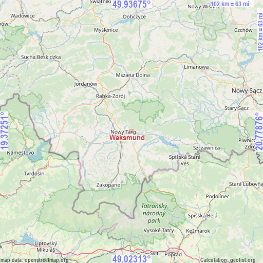
Waksmund GPS coordinates[2]
49° 28' 55.452" North, 20° 4' 32.268" East
| Map corner | latitude | longitude |
|---|---|---|
| Upper-left | 49.93675°, | 19.37251° |
| Center: | 49.48207°, | 20.07563° |
| Lower-right: | 49.02313°, | 20.77876° |
| Map W x H: | 101.6×101.6 km | = 63.1×63.1mi |
| max Lat: | 54.83135° ⇑98.4% North |
| Waksmund: | 49.48207° |
| min Lat: | ⇓1.6% South 49.21328° |
| min Long | Waksmund | max Long |
| 14.20249° | 20.07563° | 24.03723° |
| W 59.4%⇐ | ⇒40.6% E |
Elevation
Elevation of Waksmund is 575 m = 1886 ft, and this is 383.6 m = 1259 ft above average elevation for this country.
| Max E: |
974 m = 3196 ft | 1.6% |
| Waksmund | 575 m 1886 ft | |
| Avg. | 191.4 m = 628 ft | |
Min E: |
-3 m = -10 ft | 98.4% |
See also: Poland elevation on elevation.city.
Geographical zone
Waksmund is located in North temperate zone (between Tropic of Cancer and the Arctic Circle). Distance of this North polar circle is 1899.3 km =1180.2 mi to North.| Distance of | km | miles | from Waksmund |
|---|---|---|---|
| North Pole | 4505.2 | 2799.4 | to North |
| Arctic Circle | 1899.3 | 1180.2 | to North |
| Tropic Cancer | 2896 | 1799.5 | to South |
| Equator | 5501.9 | 3418.7 | to South |


Nearby cities:
15 places around Waksmund: (largest is in red/bold)
• Białka Tatrzańska
10.5 km =6.5 mi,  168°
168°
• Dębno
9.6 km =6 mi,  100°
100°
• Frydman
11.7 km =7.3 mi,  108°
108°
• Klikuszowa
7.7 km =4.8 mi,  302°
302°
• Krauszów
8.6 km =5.3 mi,  264°
264°
• Lasek
7.5 km =4.7 mi,  293°
293°
• Leśnica
9.1 km =5.7 mi,  187°
187°
• Ludźmierz
6.9 km =4.3 mi, 255°
• Nowy Targ
3.2 km =2 mi, 261°
• Ostrowsko
1.9 km =1.2 mi, 110°
• Pyzówka
10.6 km =6.6 mi, 290°
• Szaflary
7.1 km =4.4 mi,  209°
209°
• Szlembark
9.9 km =6.2 mi,  94°
94°
• Trute
7.8 km =4.8 mi,  277°
277°
• Łopuszna
4.1 km =2.5 mi, 104°
Sources, notices
• [Note1] Compared only with cities in Poland existing in our database
• [Src1] Map data: © OpenStreetMap contributors (CC-BY-SA)
• [Src2] Other city data from geonames.org with taken over terms of usage.
• [Src3] Geographical zone / Annual Mean Temperature by Robert A. Rohde @ Wikipedia
