Leśnica geodata
Leśnica (Lesser Poland) is a populated place; located in Poland in Europe/Warsaw (GMT+2) time zone. With population of 1,200 people, there are 2164 cities with bigger population in this country. Compared to other cities in Poland, 99.5% of cities are located further ↑North; 59.3% of cities are located further ←West and 99.7% of cities have lower elevation than Leśnica. Note1
Administrative division(s):
- Level 1: Lesser Poland
- Level 2: Powiat tatrzański
- Level 3: Bukowina Tatrzańska


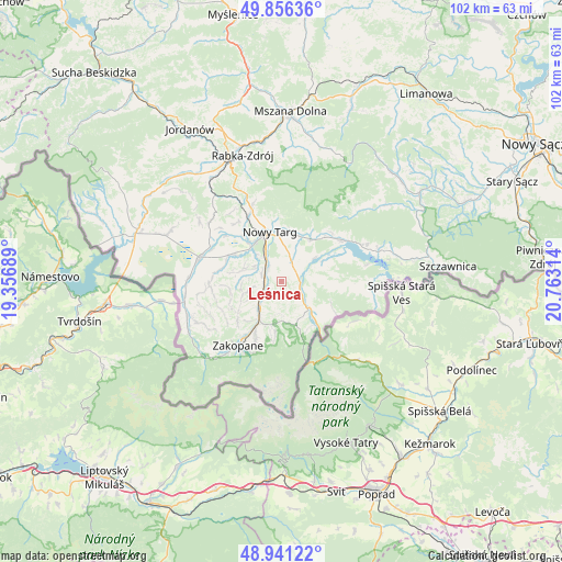
Leśnica GPS coordinates[2]
49° 24' 3.312" North, 20° 3' 36.036" East
| Map corner | latitude | longitude |
|---|---|---|
| Upper-left | 49.85636°, | 19.35689° |
| Center: | 49.40092°, | 20.06001° |
| Lower-right: | 48.94122°, | 20.76314° |
| Map W x H: | 101.8×101.8 km | = 63.3×63.3mi |
| max Lat: | 54.83135° ⇑99.5% North |
| Leśnica: | 49.40092° |
| min Lat: | ⇓0.5% South 49.21328° |
| min Long | Leśnica | max Long |
| 14.20249° | 20.06001° | 24.03723° |
| W 59.3%⇐ | ⇒40.7% E |
Elevation
Elevation of Leśnica is 704 m = 2310 ft, and this is 512.6 m = 1682 ft above average elevation for this country.
| Max E: |
974 m = 3196 ft | 0.3% |
| Leśnica | 704 m 2310 ft | |
| Avg. | 191.4 m = 628 ft | |
Min E: |
-3 m = -10 ft | 99.7% |
See also: Poland elevation on elevation.city.
Geographical zone
Leśnica is located in North temperate zone (between Tropic of Cancer and the Arctic Circle). Distance of this North polar circle is 1908.3 km =1185.8 mi to North.| Distance of | km | miles | from Leśnica |
|---|---|---|---|
| North Pole | 4514.2 | 2805 | to North |
| Arctic Circle | 1908.3 | 1185.8 | to North |
| Tropic Cancer | 2886.9 | 1793.8 | to South |
| Equator | 5492.9 | 3413.1 | to South |


Nearby cities:
15 places around Leśnica: (largest is in red/bold)
• Białka Tatrzańska
3.5 km =2.2 mi,  110°
110°
• Biały Dunajec
4.8 km =3 mi,  230°
230°
• Bukowina Tatrzańska
7.3 km =4.5 mi,  151°
151°
• Czarna Góra
5.8 km =3.6 mi,  117°
117°
• Dębno
12.8 km =8 mi,  55°
55°
• Krauszów
11.1 km =6.9 mi,  317°
317°
• Ludźmierz
9.2 km =5.7 mi, 322°
• Nowy Targ
8.8 km =5.5 mi,  346°
346°
• Ostrowsko
8.9 km =5.5 mi,  19°
19°
• Poronin
8.1 km =5 mi,  210°
210°
• Szaflary
3.7 km =2.3 mi, 320°
• Trute
12.1 km =7.5 mi,  326°
326°
• Waksmund
9.1 km =5.7 mi,  7°
7°
• Łapsze Niżne
13.3 km =8.3 mi,  91°
91°
• Łopuszna
9.5 km =5.9 mi,  32°
32°
Sources, notices
• [Note1] Compared only with cities in Poland existing in our database
• [Src1] Map data: © OpenStreetMap contributors (CC-BY-SA)
• [Src2] Other city data from geonames.org with taken over terms of usage.
• [Src3] Geographical zone / Annual Mean Temperature by Robert A. Rohde @ Wikipedia
