Spiczyn geodata
Spiczyn (Lublin) is a seat of a third-order administrative division; located in Poland in Europe/Warsaw (GMT+2) time zone. With population of 697 people, there are 3080 cities with bigger population in this country. Compared to other cities in Poland, 53.8% of cities are located further ↓South; 94.3% of cities are located further ←West and 52.1% of cities have higher elevation than Spiczyn. Note1


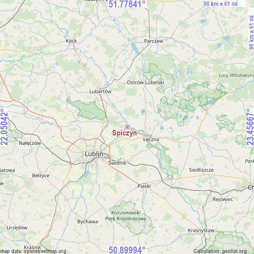
Spiczyn GPS coordinates[2]
51° 20' 28.608" North, 22° 45' 12.744" East
| Map corner | latitude | longitude |
|---|---|---|
| Upper-left | 51.77841°, | 22.05042° |
| Center: | 51.34128°, | 22.75354° |
| Lower-right: | 50.89994°, | 23.45667° |
| Map W x H: | 97.7×97.7 km | = 60.7×60.7mi |
| max Lat: | 54.83135° ⇑46.2% North |
| Spiczyn: | 51.34128° |
| min Lat: | ⇓53.8% South 49.21328° |
| min Long | Spiczyn | max Long |
| 14.20249° | 22.75354° | 24.03723° |
| W 94.3%⇐ | ⇒5.7% E |
Elevation
Elevation of Spiczyn is 166 m = 545 ft, and this is 25.4 m = 83 ft below average elevation for this country.
| Max E: |
974 m = 3196 ft | 52.1% |
| Avg. | 191.4 m = 628 ft | |
| Spiczyn | 166 m = 545 ft | |
Min E: |
-3 m = -10 ft | 47.9% |
See also: Poland elevation on elevation.city.
Geographical zone
Spiczyn is located in North temperate zone (between Tropic of Cancer and the Arctic Circle). Distance of this North polar circle is 1692.6 km =1051.7 mi to North.| Distance of | km | miles | from Spiczyn |
|---|---|---|---|
| North Pole | 4298.4 | 2670.9 | to North |
| Arctic Circle | 1692.6 | 1051.7 | to North |
| Tropic Cancer | 3102.7 | 1927.9 | to South |
| Equator | 5708.6 | 3547.2 | to South |


Nearby cities:
15 places around Spiczyn: (largest is in red/bold)
• Jakubowice Murowane
11.5 km =7.1 mi,  226°
226°
• Krasne
16.3 km =10.1 mi,  59°
59°
• Lubartów
16.6 km =10.3 mi,  322°
322°
• Lublin
16.5 km =10.3 mi, 232°
• Ludwin
10.6 km =6.6 mi,  87°
87°
• Mełgiew
13.1 km =8.1 mi,  170°
170°
• Milejów
17 km =10.6 mi,  135°
135°
• Niemce
8.2 km =5.1 mi,  285°
285°
• Pałecznica
16.8 km =10.4 mi,  340°
340°
• Puchaczów
15.7 km =9.8 mi,  102°
102°
• Serniki
12.5 km =7.8 mi,  328°
328°
• Wola Sernicka
13 km =8.1 mi, 338°
• Wólka
11.7 km =7.3 mi,  223°
223°
• Łęczna
9.9 km =6.2 mi,  116°
116°
• Świdnik
14.2 km =8.8 mi,  196°
196°
Sources, notices
• [Note1] Compared only with cities in Poland existing in our database
• [Src1] Map data: © OpenStreetMap contributors (CC-BY-SA)
• [Src2] Other city data from geonames.org with taken over terms of usage.
• [Src3] Geographical zone / Annual Mean Temperature by Robert A. Rohde @ Wikipedia
