Pałecznica geodata
Pałecznica (Lublin) is a populated place; located in Poland in Europe/Warsaw (GMT+2) time zone. With population of 854 people, there are 2767 cities with bigger population in this country. Compared to other cities in Poland, 56.1% of cities are located further ↓South; 93.6% of cities are located further ←West and 54.2% of cities have higher elevation than Pałecznica. Note1


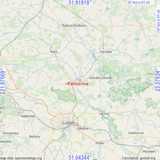
Pałecznica GPS coordinates[2]
51° 29' 0.276" North, 22° 40' 23.556" East
| Map corner | latitude | longitude |
|---|---|---|
| Upper-left | 51.91918°, | 21.97009° |
| Center: | 51.48341°, | 22.67321° |
| Lower-right: | 51.04344°, | 23.37634° |
| Map W x H: | 97.4×97.4 km | = 60.5×60.5mi |
| max Lat: | 54.83135° ⇑43.9% North |
| Pałecznica: | 51.48341° |
| min Lat: | ⇓56.1% South 49.21328° |
| min Long | Pałecznica | max Long |
| 14.20249° | 22.67321° | 24.03723° |
| W 93.6%⇐ | ⇒6.4% E |
Elevation
Elevation of Pałecznica is 161 m = 528 ft, and this is 30.4 m = 100 ft below average elevation for this country.
| Max E: |
974 m = 3196 ft | 54.2% |
| Avg. | 191.4 m = 628 ft | |
| Pałecznica | 161 m = 528 ft | |
Min E: |
-3 m = -10 ft | 45.8% |
See also: Poland elevation on elevation.city.
Geographical zone
Pałecznica is located in North temperate zone (between Tropic of Cancer and the Arctic Circle). Distance of this North polar circle is 1676.8 km =1041.9 mi to North.| Distance of | km | miles | from Pałecznica |
|---|---|---|---|
| North Pole | 4282.6 | 2661.1 | to North |
| Arctic Circle | 1676.8 | 1041.9 | to North |
| Tropic Cancer | 3118.5 | 1937.7 | to South |
| Equator | 5724.4 | 3557 | to South |


Nearby cities:
15 places around Pałecznica: (largest is in red/bold)
• Brzeźnica Bychawska
7.3 km =4.5 mi,  47°
47°
• Firlej
14.2 km =8.8 mi,  306°
306°
• Kamionka
14.6 km =9.1 mi,  264°
264°
• Kozłówka
12.8 km =8 mi,  252°
252°
• Lubartów
5.1 km =3.2 mi,  239°
239°
• Niedźwiada
6.9 km =4.3 mi,  10°
10°
• Niemce
13.8 km =8.6 mi,  189°
189°
• Ostrów Lubelski
12.5 km =7.8 mi,  84°
84°
• Ostrówek
11.7 km =7.3 mi,  338°
338°
• Serniki
5.2 km =3.2 mi, 191°
• Siemień
17.6 km =10.9 mi,  22°
22°
• Spiczyn
16.8 km =10.4 mi,  160°
160°
• Uścimów Nowy
17.4 km =10.8 mi,  97°
97°
• Uścimów Stary
19.6 km =12.2 mi,  94°
94°
• Wola Sernicka
3.8 km =2.4 mi,  169°
169°
Sources, notices
• [Note1] Compared only with cities in Poland existing in our database
• [Src1] Map data: © OpenStreetMap contributors (CC-BY-SA)
• [Src2] Other city data from geonames.org with taken over terms of usage.
• [Src3] Geographical zone / Annual Mean Temperature by Robert A. Rohde @ Wikipedia
