Łęczna geodata
Łęczna (Lublin) is a seat of a second-order administrative division; located in Poland in Europe/Warsaw (GMT+2) time zone. With population of 21,719 people, there are 229 cities with bigger population in this country. Compared to other cities in Poland, 53.2% of cities are located further ↓South; 95.1% of cities are located further ←West and 50.2% of cities have lower elevation than Łęczna. Note1


Łęczna GPS coordinates[2]
51° 18' 4.356" North, 22° 52' 52.86" East
| Map corner | latitude | longitude |
|---|---|---|
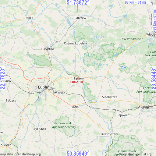
| Upper-left | 51.73872°, | 22.17823° |
| Center: | 51.30121°, | 22.88135° |
| Lower-right: | 50.85949°, | 23.58448° |
| Map W x H: | 97.8×97.8 km | = 60.8×60.8mi |
| max Lat: | 54.83135° ⇑46.8% North |
| Łęczna: | 51.30121° |
| min Lat: | ⇓53.2% South 49.21328° |
| min Long | Łęczna | max Long |
| 14.20249° | 22.88135° | 24.03723° |
| W 95.1%⇐ | ⇒4.9% E |
Elevation
Elevation of Łęczna is 172 m = 564 ft, and this is 19.4 m = 64 ft below average elevation for this country.
| Max E: |
974 m = 3196 ft | 49.8% |
| Avg. | 191.4 m = 628 ft | |
| Łęczna | 172 m = 564 ft | |
Min E: |
-3 m = -10 ft | 50.2% |
See also: Poland elevation on elevation.city.
Geographical zone
Łęczna is located in North temperate zone (between Tropic of Cancer and the Arctic Circle). Distance of this North polar circle is 1697 km =1054.5 mi to North.| Distance of | km | miles | from Łęczna |
|---|---|---|---|
| North Pole | 4302.9 | 2673.7 | to North |
| Arctic Circle | 1697 | 1054.5 | to North |
| Tropic Cancer | 3098.2 | 1925.1 | to South |
| Equator | 5704.2 | 3544.4 | to South |


Nearby cities:
15 places around Łęczna: (largest is in red/bold)
• Cyców
18.1 km =11.2 mi,  90°
90°
• Jakubowice Murowane
17.5 km =10.9 mi,  258°
258°
• Krasne
13.7 km =8.5 mi,  22°
22°
• Ludwin
5.3 km =3.3 mi, 18°
• Mełgiew
10.8 km =6.7 mi,  218°
218°
• Milejów
8.2 km =5.1 mi,  158°
158°
• Niemce
18.1 km =11.2 mi,  291°
291°
• Piaski
18.2 km =11.3 mi,  187°
187°
• Puchaczów
6.5 km =4 mi,  80°
80°
• Spiczyn
9.9 km =6.2 mi,  296°
296°
• Trawniki
20.1 km =12.5 mi, 156°
• Uścimów Nowy
18.1 km =11.2 mi,  9°
9°
• Uścimów Stary
19.4 km =12.1 mi, 15°
• Wólka
17.4 km =10.8 mi, 256°
• Świdnik
15.8 km =9.8 mi,  234°
234°
Sources, notices
• [Note1] Compared only with cities in Poland existing in our database
• [Src1] Map data: © OpenStreetMap contributors (CC-BY-SA)
• [Src2] Other city data from geonames.org with taken over terms of usage.
• [Src3] Geographical zone / Annual Mean Temperature by Robert A. Rohde @ Wikipedia
