Niemce geodata
Niemce (Lublin) is a seat of a third-order administrative division; located in Poland in Europe/Warsaw (GMT+2) time zone. With population of 3,161 people, there are 1001 cities with bigger population in this country. Compared to other cities in Poland, 54.2% of cities are located further ↓South; 93.2% of cities are located further ←West and 54.6% of cities have lower elevation than Niemce. Note1


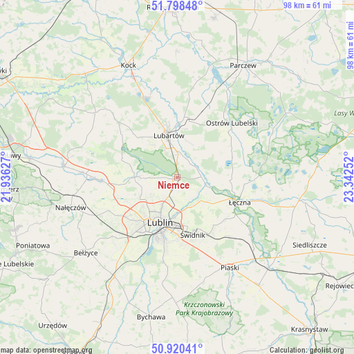
Niemce GPS coordinates[2]
51° 21' 41.58" North, 22° 38' 21.804" East
| Map corner | latitude | longitude |
|---|---|---|
| Upper-left | 51.79848°, | 21.93627° |
| Center: | 51.36155°, | 22.63939° |
| Lower-right: | 50.92041°, | 23.34252° |
| Map W x H: | 97.6×97.6 km | = 60.6×60.6mi |
| max Lat: | 54.83135° ⇑45.8% North |
| Niemce: | 51.36155° |
| min Lat: | ⇓54.2% South 49.21328° |
| min Long | Niemce | max Long |
| 14.20249° | 22.63939° | 24.03723° |
| W 93.2%⇐ | ⇒6.8% E |
Elevation
Elevation of Niemce is 184 m = 604 ft, and this is 7.4 m = 24 ft below average elevation for this country.
| Max E: |
974 m = 3196 ft | 45.4% |
| Avg. | 191.4 m = 628 ft | |
| Niemce | 184 m = 604 ft | |
Min E: |
-3 m = -10 ft | 54.6% |
See also: Poland elevation on elevation.city.
Geographical zone
Niemce is located in North temperate zone (between Tropic of Cancer and the Arctic Circle). Distance of this North polar circle is 1690.3 km =1050.3 mi to North.| Distance of | km | miles | from Niemce |
|---|---|---|---|
| North Pole | 4296.2 | 2669.5 | to North |
| Arctic Circle | 1690.3 | 1050.3 | to North |
| Tropic Cancer | 3105 | 1929.4 | to South |
| Equator | 5710.9 | 3548.6 | to South |


Nearby cities:
15 places around Niemce: (largest is in red/bold)
• Jakubowice Murowane
10.2 km =6.3 mi,  182°
182°
• Jastków
15.5 km =9.6 mi,  245°
245°
• Kamionka
17.3 km =10.7 mi,  314°
314°
• Kozłówka
13.9 km =8.6 mi, 314°
• Lubartów
11.2 km =7 mi,  349°
349°
• Lublin
13.4 km =8.3 mi,  202°
202°
• Ludwin
18.6 km =11.6 mi,  95°
95°
• Mełgiew
18.2 km =11.3 mi,  146°
146°
• Pałecznica
13.8 km =8.6 mi,  9°
9°
• Serniki
8.5 km =5.3 mi, 8°
• Spiczyn
8.2 km =5.1 mi,  105°
105°
• Wola Sernicka
10.3 km =6.4 mi,  17°
17°
• Wólka
10.8 km =6.7 mi, 180°
• Łęczna
18.1 km =11.2 mi, 111°
• Świdnik
16.3 km =10.1 mi,  166°
166°
Sources, notices
• [Note1] Compared only with cities in Poland existing in our database
• [Src1] Map data: © OpenStreetMap contributors (CC-BY-SA)
• [Src2] Other city data from geonames.org with taken over terms of usage.
• [Src3] Geographical zone / Annual Mean Temperature by Robert A. Rohde @ Wikipedia
