Przybysławice geodata
Przybysławice (Lesser Poland) is a populated place; located in Poland in Europe/Warsaw (GMT+2) time zone. With population of 557 people, there are 3392 cities with bigger population in this country. Compared to other cities in Poland, 75.6% of cities are located further ↑North; 69.1% of cities are located further ←West and 52% of cities have lower elevation than Przybysławice. Note1


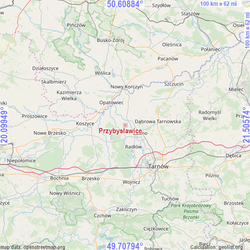
Przybysławice GPS coordinates[2]
50° 9' 37.836" North, 20° 48' 9.396" East
| Map corner | latitude | longitude |
|---|---|---|
| Upper-left | 50.60884°, | 20.09949° |
| Center: | 50.16051°, | 20.80261° |
| Lower-right: | 49.70794°, | 21.50574° |
| Map W x H: | 100.2×100.2 km | = 62.3×62.3mi |
| max Lat: | 54.83135° ⇑75.6% North |
| Przybysławice: | 50.16051° |
| min Lat: | ⇓24.4% South 49.21328° |
| min Long | Przybysławice | max Long |
| 14.20249° | 20.80261° | 24.03723° |
| W 69.1%⇐ | ⇒30.9% E |
Elevation
Elevation of Przybysławice is 177 m = 581 ft, and this is 14.4 m = 47 ft below average elevation for this country.
| Max E: |
974 m = 3196 ft | 48% |
| Avg. | 191.4 m = 628 ft | |
| Przybysławice | 177 m = 581 ft | |
Min E: |
-3 m = -10 ft | 52% |
See also: Poland elevation on elevation.city.
Geographical zone
Przybysławice is located in North temperate zone (between Tropic of Cancer and the Arctic Circle). Distance of this North polar circle is 1823.8 km =1133.3 mi to North.| Distance of | km | miles | from Przybysławice |
|---|---|---|---|
| North Pole | 4429.7 | 2752.5 | to North |
| Arctic Circle | 1823.8 | 1133.3 | to North |
| Tropic Cancer | 2971.4 | 1846.3 | to South |
| Equator | 5577.3 | 3465.6 | to South |


Nearby cities:
15 places around Przybysławice: (largest is in red/bold)
• Biskupice Radłowskie
6 km =3.7 mi,  137°
137°
• Gorzyce
4.9 km =3 mi,  57°
57°
• Gręboszów
9.6 km =6 mi,  348°
348°
• Jadowniki Mokre
5.3 km =3.3 mi,  275°
275°
• Miechowice Małe
2.5 km =1.6 mi,  292°
292°
• Miechowice Wielkie
5.4 km =3.4 mi,  309°
309°
• Nieciecza
3.5 km =2.2 mi,  104°
104°
• Niedomice
8.9 km =5.5 mi,  131°
131°
• Odporyszów
7.9 km =4.9 mi, 96°
• Radłów
9.1 km =5.7 mi,  158°
158°
• Sieradza
9.5 km =5.9 mi,  107°
107°
• Wietrzychowice
4.3 km =2.7 mi,  321°
321°
• Zabawa
4.7 km =2.9 mi, 162°
• Zaborów
8.1 km =5 mi,  259°
259°
• Żabno
6.7 km =4.2 mi,  116°
116°
Sources, notices
• [Note1] Compared only with cities in Poland existing in our database
• [Src1] Map data: © OpenStreetMap contributors (CC-BY-SA)
• [Src2] Other city data from geonames.org with taken over terms of usage.
• [Src3] Geographical zone / Annual Mean Temperature by Robert A. Rohde @ Wikipedia
