Zabawa geodata
Zabawa (Lesser Poland) is a populated place; located in Poland in Europe/Warsaw (GMT+2) time zone. With population of 920 people, there are 2637 cities with bigger population in this country. Compared to other cities in Poland, 77.2% of cities are located further ↑North; 69.5% of cities are located further ←West and 52.6% of cities have lower elevation than Zabawa. Note1


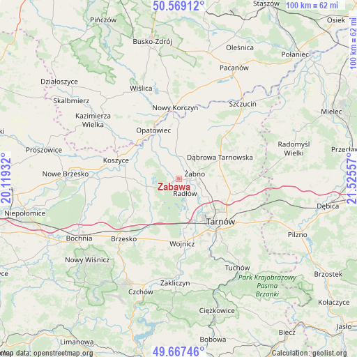
Zabawa GPS coordinates[2]
50° 7' 13.476" North, 20° 49' 20.784" East
| Map corner | latitude | longitude |
|---|---|---|
| Upper-left | 50.56912°, | 20.11932° |
| Center: | 50.12041°, | 20.82244° |
| Lower-right: | 49.66746°, | 21.52557° |
| Map W x H: | 100.3×100.3 km | = 62.3×62.3mi |
| max Lat: | 54.83135° ⇑77.2% North |
| Zabawa: | 50.12041° |
| min Lat: | ⇓22.8% South 49.21328° |
| min Long | Zabawa | max Long |
| 14.20249° | 20.82244° | 24.03723° |
| W 69.5%⇐ | ⇒30.5% E |
Elevation
Elevation of Zabawa is 179 m = 587 ft, and this is 12.4 m = 41 ft below average elevation for this country.
| Max E: |
974 m = 3196 ft | 47.4% |
| Avg. | 191.4 m = 628 ft | |
| Zabawa | 179 m = 587 ft | |
Min E: |
-3 m = -10 ft | 52.6% |
See also: Poland elevation on elevation.city.
Geographical zone
Zabawa is located in North temperate zone (between Tropic of Cancer and the Arctic Circle). Distance of this North polar circle is 1828.3 km =1136.1 mi to North.| Distance of | km | miles | from Zabawa |
|---|---|---|---|
| North Pole | 4434.2 | 2755.3 | to North |
| Arctic Circle | 1828.3 | 1136.1 | to North |
| Tropic Cancer | 2966.9 | 1843.5 | to South |
| Equator | 5572.9 | 3462.8 | to South |


Nearby cities:
15 places around Zabawa: (largest is in red/bold)
• Biskupice Radłowskie
2.6 km =1.6 mi,  89°
89°
• Borzęcin
10 km =6.2 mi,  232°
232°
• Gorzyce
7.6 km =4.7 mi,  21°
21°
• Jadowniki Mokre
8.4 km =5.2 mi,  306°
306°
• Miechowice Małe
6.6 km =4.1 mi,  325°
325°
• Miechowice Wielkie
9.6 km =6 mi,  324°
324°
• Nieciecza
4.1 km =2.5 mi,  28°
28°
• Niedomice
5.4 km =3.4 mi,  105°
105°
• Odporyszów
7.3 km =4.5 mi,  61°
61°
• Przybysławice
4.7 km =2.9 mi,  342°
342°
• Radłów
4.5 km =2.8 mi,  154°
154°
• Sieradza
7.8 km =4.8 mi,  78°
78°
• Wietrzychowice
8.8 km =5.5 mi, 332°
• Zaborów
9.9 km =6.2 mi,  287°
287°
• Żabno
4.8 km =3 mi,  72°
72°
Sources, notices
• [Note1] Compared only with cities in Poland existing in our database
• [Src1] Map data: © OpenStreetMap contributors (CC-BY-SA)
• [Src2] Other city data from geonames.org with taken over terms of usage.
• [Src3] Geographical zone / Annual Mean Temperature by Robert A. Rohde @ Wikipedia
