Żabno geodata
Żabno (Lesser Poland) is a seat of a third-order administrative division; located in Poland in Europe/Warsaw (GMT+2) time zone. With population of 4,250 people, there are 772 cities with bigger population in this country. Compared to other cities in Poland, 76.7% of cities are located further ↑North; 70.6% of cities are located further ←West and 55.2% of cities have lower elevation than Żabno. Note1


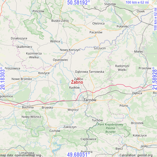
Żabno GPS coordinates[2]
50° 8' 0.024" North, 20° 53' 10.14" East
| Map corner | latitude | longitude |
|---|---|---|
| Upper-left | 50.58192°, | 20.18303° |
| Center: | 50.13334°, | 20.88615° |
| Lower-right: | 49.68051°, | 21.58928° |
| Map W x H: | 100.2×100.2 km | = 62.3×62.3mi |
| max Lat: | 54.83135° ⇑76.7% North |
| Żabno: | 50.13334° |
| min Lat: | ⇓23.3% South 49.21328° |
| min Long | Żabno | max Long |
| 14.20249° | 20.88615° | 24.03723° |
| W 70.6%⇐ | ⇒29.4% E |
Elevation
Elevation of Żabno is 186 m = 610 ft, and this is 5.4 m = 18 ft below average elevation for this country.
| Max E: |
974 m = 3196 ft | 44.8% |
| Avg. | 191.4 m = 628 ft | |
| Żabno | 186 m = 610 ft | |
Min E: |
-3 m = -10 ft | 55.2% |
See also: Poland elevation on elevation.city.
Geographical zone
Żabno is located in North temperate zone (between Tropic of Cancer and the Arctic Circle). Distance of this North polar circle is 1826.9 km =1135.2 mi to North.| Distance of | km | miles | from Żabno |
|---|---|---|---|
| North Pole | 4432.8 | 2754.4 | to North |
| Arctic Circle | 1826.9 | 1135.2 | to North |
| Tropic Cancer | 2968.4 | 1844.5 | to South |
| Equator | 5574.3 | 3463.7 | to South |


Nearby cities:
15 places around Żabno: (largest is in red/bold)
• Biskupice Radłowskie
2.4 km =1.5 mi,  233°
233°
• Dąbrowa Tarnowska
8.5 km =5.3 mi,  57°
57°
• Gorzyce
5.9 km =3.7 mi,  342°
342°
• Miechowice Małe
9.2 km =5.7 mi,  295°
295°
• Nieciecza
3.4 km =2.1 mi,  309°
309°
• Niedomice
3 km =1.9 mi,  167°
167°
• Odporyszów
2.8 km =1.7 mi,  41°
41°
• Olesno
8.1 km =5 mi,  20°
20°
• Przybysławice
6.7 km =4.2 mi, 296°
• Radłów
6.1 km =3.8 mi,  205°
205°
• Sieradza
3.1 km =1.9 mi,  86°
86°
• Swarzów
8.5 km =5.3 mi, 35°
• Wietrzychowice
10.7 km =6.6 mi, 306°
• Zabawa
4.8 km =3 mi,  252°
252°
• Łukowa
7.8 km =4.8 mi,  125°
125°
Sources, notices
• [Note1] Compared only with cities in Poland existing in our database
• [Src1] Map data: © OpenStreetMap contributors (CC-BY-SA)
• [Src2] Other city data from geonames.org with taken over terms of usage.
• [Src3] Geographical zone / Annual Mean Temperature by Robert A. Rohde @ Wikipedia
