Nieciecza geodata
Nieciecza (Lesser Poland) is a populated place; located in Poland in Europe/Warsaw (GMT+2) time zone. With population of 728 people, there are 3012 cities with bigger population in this country. Compared to other cities in Poland, 75.9% of cities are located further ↑North; 69.8% of cities are located further ←West and 52.3% of cities have lower elevation than Nieciecza. Note1


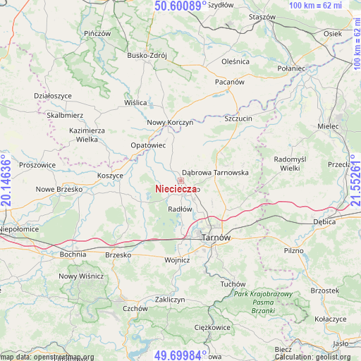
Nieciecza GPS coordinates[2]
50° 9' 8.964" North, 20° 50' 58.128" East
| Map corner | latitude | longitude |
|---|---|---|
| Upper-left | 50.60089°, | 20.14636° |
| Center: | 50.15249°, | 20.84948° |
| Lower-right: | 49.69984°, | 21.55261° |
| Map W x H: | 100.2×100.2 km | = 62.3×62.3mi |
| max Lat: | 54.83135° ⇑75.9% North |
| Nieciecza: | 50.15249° |
| min Lat: | ⇓24.1% South 49.21328° |
| min Long | Nieciecza | max Long |
| 14.20249° | 20.84948° | 24.03723° |
| W 69.8%⇐ | ⇒30.2% E |
Elevation
Elevation of Nieciecza is 178 m = 584 ft, and this is 13.4 m = 44 ft below average elevation for this country.
| Max E: |
974 m = 3196 ft | 47.7% |
| Avg. | 191.4 m = 628 ft | |
| Nieciecza | 178 m = 584 ft | |
Min E: |
-3 m = -10 ft | 52.3% |
See also: Poland elevation on elevation.city.
Geographical zone
Nieciecza is located in North temperate zone (between Tropic of Cancer and the Arctic Circle). Distance of this North polar circle is 1824.7 km =1133.8 mi to North.| Distance of | km | miles | from Nieciecza |
|---|---|---|---|
| North Pole | 4430.6 | 2753 | to North |
| Arctic Circle | 1824.7 | 1133.8 | to North |
| Tropic Cancer | 2970.5 | 1845.8 | to South |
| Equator | 5576.4 | 3465 | to South |


Nearby cities:
15 places around Nieciecza: (largest is in red/bold)
• Biskupice Radłowskie
3.6 km =2.2 mi,  168°
168°
• Gorzyce
3.6 km =2.2 mi,  12°
12°
• Jadowniki Mokre
8.7 km =5.4 mi,  279°
279°
• Miechowice Małe
6 km =3.7 mi,  287°
287°
• Miechowice Wielkie
8.6 km =5.3 mi,  299°
299°
• Niedomice
6 km =3.7 mi,  146°
146°
• Odporyszów
4.5 km =2.8 mi,  90°
90°
• Olesno
7.7 km =4.8 mi,  44°
44°
• Przybysławice
3.5 km =2.2 mi, 284°
• Radłów
7.6 km =4.7 mi,  179°
179°
• Sieradza
6 km =3.7 mi,  108°
108°
• Swarzów
8.9 km =5.5 mi,  57°
57°
• Wietrzychowice
7.4 km =4.6 mi,  305°
305°
• Zabawa
4.1 km =2.5 mi,  208°
208°
• Żabno
3.4 km =2.1 mi,  129°
129°
Sources, notices
• [Note1] Compared only with cities in Poland existing in our database
• [Src1] Map data: © OpenStreetMap contributors (CC-BY-SA)
• [Src2] Other city data from geonames.org with taken over terms of usage.
• [Src3] Geographical zone / Annual Mean Temperature by Robert A. Rohde @ Wikipedia
