Wietrzychowice geodata
Wietrzychowice (Lesser Poland) is a seat of a third-order administrative division; located in Poland in Europe/Warsaw (GMT+2) time zone. With population of 658 people, there are 3151 cities with bigger population in this country. Compared to other cities in Poland, 74.9% of cities are located further ↑North; 68.6% of cities are located further ←West and 51.5% of cities have lower elevation than Wietrzychowice. Note1
Administrative division(s):
- Level 1: Lesser Poland
- Level 2: Powiat tarnowski
- Level 3: Wietrzychowice


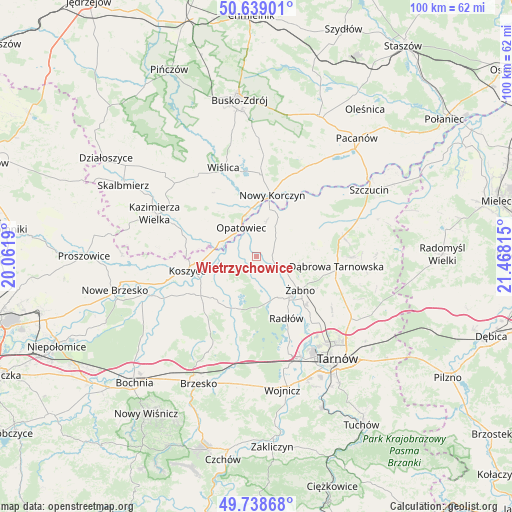
Wietrzychowice GPS coordinates[2]
50° 11' 27.492" North, 20° 45' 54.072" East
| Map corner | latitude | longitude |
|---|---|---|
| Upper-left | 50.63901°, | 20.0619° |
| Center: | 50.19097°, | 20.76502° |
| Lower-right: | 49.73868°, | 21.46815° |
| Map W x H: | 100.1×100.1 km | = 62.2×62.2mi |
| max Lat: | 54.83135° ⇑74.9% North |
| Wietrzychowice: | 50.19097° |
| min Lat: | ⇓25.1% South 49.21328° |
| min Long | Wietrzychowice | max Long |
| 14.20249° | 20.76502° | 24.03723° |
| W 68.6%⇐ | ⇒31.4% E |
Elevation
Elevation of Wietrzychowice is 176 m = 577 ft, and this is 15.4 m = 51 ft below average elevation for this country.
| Max E: |
974 m = 3196 ft | 48.5% |
| Avg. | 191.4 m = 628 ft | |
| Wietrzychowice | 176 m = 577 ft | |
Min E: |
-3 m = -10 ft | 51.5% |
See also: Poland elevation on elevation.city.
Geographical zone
Wietrzychowice is located in North temperate zone (between Tropic of Cancer and the Arctic Circle). Distance of this North polar circle is 1820.5 km =1131.2 mi to North.| Distance of | km | miles | from Wietrzychowice |
|---|---|---|---|
| North Pole | 4426.3 | 2750.4 | to North |
| Arctic Circle | 1820.5 | 1131.2 | to North |
| Tropic Cancer | 2974.8 | 1848.5 | to South |
| Equator | 5580.7 | 3467.7 | to South |


Nearby cities:
15 places around Wietrzychowice: (largest is in red/bold)
• Biskupice Radłowskie
10.3 km =6.4 mi,  139°
139°
• Gorzyce
6.9 km =4.3 mi,  96°
96°
• Gręboszów
6.1 km =3.8 mi,  7°
7°
• Jadowniki Mokre
3.9 km =2.4 mi,  222°
222°
• Miechowice Małe
2.5 km =1.6 mi,  171°
171°
• Miechowice Wielkie
1.5 km =0.9 mi,  270°
270°
• Nieciecza
7.4 km =4.6 mi,  125°
125°
• Odporyszów
11.3 km =7 mi,  112°
112°
• Olesno
11.5 km =7.1 mi,  84°
84°
• Opatowiec
6.5 km =4 mi,  333°
333°
• Przybysławice
4.3 km =2.7 mi, 141°
• Szczurowa
12.2 km =7.6 mi,  228°
228°
• Zabawa
8.8 km =5.5 mi,  152°
152°
• Zaborów
7.2 km =4.5 mi, 227°
• Żabno
10.7 km =6.6 mi, 126°
Sources, notices
• [Note1] Compared only with cities in Poland existing in our database
• [Src1] Map data: © OpenStreetMap contributors (CC-BY-SA)
• [Src2] Other city data from geonames.org with taken over terms of usage.
• [Src3] Geographical zone / Annual Mean Temperature by Robert A. Rohde @ Wikipedia
