Zaborów geodata
Zaborów (Lesser Poland) is a populated place; located in Poland in Europe/Warsaw (GMT+2) time zone. With population of 560 people, there are 3377 cities with bigger population in this country. Compared to other cities in Poland, 76.2% of cities are located further ↑North; 67.4% of cities are located further ←West and 53% of cities have lower elevation than Zaborów. Note1


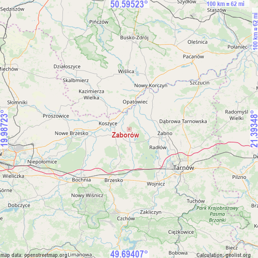
Zaborów GPS coordinates[2]
50° 8' 48.372" North, 20° 41' 25.26" East
| Map corner | latitude | longitude |
|---|---|---|
| Upper-left | 50.59523°, | 19.98723° |
| Center: | 50.14677°, | 20.69035° |
| Lower-right: | 49.69407°, | 21.39348° |
| Map W x H: | 100.2×100.2 km | = 62.3×62.3mi |
| max Lat: | 54.83135° ⇑76.2% North |
| Zaborów: | 50.14677° |
| min Lat: | ⇓23.8% South 49.21328° |
| min Long | Zaborów | max Long |
| 14.20249° | 20.69035° | 24.03723° |
| W 67.4%⇐ | ⇒32.6% E |
Elevation
Elevation of Zaborów is 180 m = 591 ft, and this is 11.4 m = 37 ft below average elevation for this country.
| Max E: |
974 m = 3196 ft | 47% |
| Avg. | 191.4 m = 628 ft | |
| Zaborów | 180 m = 591 ft | |
Min E: |
-3 m = -10 ft | 53% |
See also: Poland elevation on elevation.city.
Geographical zone
Zaborów is located in North temperate zone (between Tropic of Cancer and the Arctic Circle). Distance of this North polar circle is 1825.4 km =1134.3 mi to North.| Distance of | km | miles | from Zaborów |
|---|---|---|---|
| North Pole | 4431.3 | 2753.5 | to North |
| Arctic Circle | 1825.4 | 1134.3 | to North |
| Tropic Cancer | 2969.9 | 1845.4 | to South |
| Equator | 5575.8 | 3464.6 | to South |


Nearby cities:
15 places around Zaborów: (largest is in red/bold)
• Bejsce
12.2 km =7.6 mi,  327°
327°
• Biskupice Radłowskie
12.4 km =7.7 mi,  103°
103°
• Borzęcin
9.2 km =5.7 mi,  170°
170°
• Jadowniki Mokre
3.4 km =2.1 mi,  52°
52°
• Koszyce
8.3 km =5.2 mi,  288°
288°
• Miechowice Małe
6.2 km =3.9 mi,  66°
66°
• Miechowice Wielkie
6.2 km =3.9 mi,  37°
37°
• Nieciecza
11.4 km =7.1 mi,  86°
86°
• Opatowiec
11 km =6.8 mi,  12°
12°
• Przybysławice
8.1 km =5 mi,  79°
79°
• Rudy-Rysie
10.2 km =6.3 mi,  201°
201°
• Strzelce Wielkie
9.8 km =6.1 mi,  233°
233°
• Szczurowa
4.9 km =3 mi, 231°
• Wietrzychowice
7.2 km =4.5 mi, 47°
• Zabawa
9.9 km =6.2 mi,  107°
107°
Sources, notices
• [Note1] Compared only with cities in Poland existing in our database
• [Src1] Map data: © OpenStreetMap contributors (CC-BY-SA)
• [Src2] Other city data from geonames.org with taken over terms of usage.
• [Src3] Geographical zone / Annual Mean Temperature by Robert A. Rohde @ Wikipedia
