Przeworsk geodata
Przeworsk (Subcarpathian) is a seat of a second-order administrative division; located in Poland in Europe/Warsaw (GMT+2) time zone. With population of 15,805 people, there are 315 cities with bigger population in this country. Compared to other cities in Poland, 79.7% of cities are located further ↑North; 91.5% of cities are located further ←West and 60.3% of cities have lower elevation than Przeworsk. Note1


Przeworsk GPS coordinates[2]
50° 3' 32.832" North, 22° 29' 38.688" East
| Map corner | latitude | longitude |
|---|---|---|
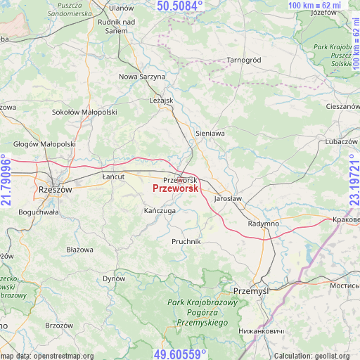
| Upper-left | 50.5084°, | 21.79096° |
| Center: | 50.05912°, | 22.49408° |
| Lower-right: | 49.60559°, | 23.19721° |
| Map W x H: | 100.4×100.4 km | = 62.4×62.4mi |
| max Lat: | 54.83135° ⇑79.7% North |
| Przeworsk: | 50.05912° |
| min Lat: | ⇓20.3% South 49.21328° |
| min Long | Przeworsk | max Long |
| 14.20249° | 22.49408° | 24.03723° |
| W 91.5%⇐ | ⇒8.5% E |
Elevation
Elevation of Przeworsk is 201 m = 659 ft, and this is 9.6 m = 31 ft above average elevation for this country.
| Max E: |
974 m = 3196 ft | 39.7% |
| Przeworsk | 201 m 659 ft | |
| Avg. | 191.4 m = 628 ft | |
Min E: |
-3 m = -10 ft | 60.3% |
See also: Poland elevation on elevation.city.
Geographical zone
Przeworsk is located in North temperate zone (between Tropic of Cancer and the Arctic Circle). Distance of this North polar circle is 1835.1 km =1140.3 mi to North.| Distance of | km | miles | from Przeworsk |
|---|---|---|---|
| North Pole | 4441 | 2759.5 | to North |
| Arctic Circle | 1835.1 | 1140.3 | to North |
| Tropic Cancer | 2960.1 | 1839.3 | to South |
| Equator | 5566.1 | 3458.6 | to South |


Nearby cities:
15 places around Przeworsk: (largest is in red/bold)
• Dębów
4.4 km =2.7 mi,  249°
249°
• Gorliczyna
3.7 km =2.3 mi,  352°
352°
• Grzęska
3.9 km =2.4 mi,  312°
312°
• Jagiełła
6.9 km =4.3 mi,  54°
54°
• Krzeczowice
8.1 km =5 mi,  195°
195°
• Maćkówka
3.7 km =2.3 mi,  153°
153°
• Mirocin
4.8 km =3 mi,  112°
112°
• Nowosielce
6 km =3.7 mi,  268°
268°
• Rozbórz
3.8 km =2.4 mi,  95°
95°
• Ujezna
6.9 km =4.3 mi,  81°
81°
• Urzejowice
5.7 km =3.5 mi, 203°
• Wierzbna
8.2 km =5.1 mi, 110°
• Zalesie
5.9 km =3.7 mi, 152°
• Zarzecze
8.7 km =5.4 mi,  159°
159°
• Żurawiczki
5.1 km =3.2 mi,  175°
175°
Sources, notices
• [Note1] Compared only with cities in Poland existing in our database
• [Src1] Map data: © OpenStreetMap contributors (CC-BY-SA)
• [Src2] Other city data from geonames.org with taken over terms of usage.
• [Src3] Geographical zone / Annual Mean Temperature by Robert A. Rohde @ Wikipedia
