Urzejowice geodata
Urzejowice (Subcarpathian) is a populated place; located in Poland in Europe/Warsaw (GMT+2) time zone. With population of 1,800 people, there are 1605 cities with bigger population in this country. Compared to other cities in Poland, 82% of cities are located further ↑North; 91.1% of cities are located further ←West and 59.4% of cities have lower elevation than Urzejowice. Note1


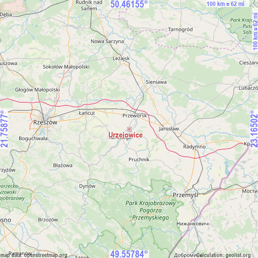
Urzejowice GPS coordinates[2]
50° 0' 42.552" North, 22° 27' 42.804" East
| Map corner | latitude | longitude |
|---|---|---|
| Upper-left | 50.46155°, | 21.75877° |
| Center: | 50.01182°, | 22.46189° |
| Lower-right: | 49.55784°, | 23.16502° |
| Map W x H: | 100.5×100.5 km | = 62.4×62.4mi |
| max Lat: | 54.83135° ⇑82% North |
| Urzejowice: | 50.01182° |
| min Lat: | ⇓18% South 49.21328° |
| min Long | Urzejowice | max Long |
| 14.20249° | 22.46189° | 24.03723° |
| W 91.1%⇐ | ⇒8.9% E |
Elevation
Elevation of Urzejowice is 199 m = 653 ft, and this is 7.6 m = 25 ft above average elevation for this country.
| Max E: |
974 m = 3196 ft | 40.6% |
| Urzejowice | 199 m 653 ft | |
| Avg. | 191.4 m = 628 ft | |
Min E: |
-3 m = -10 ft | 59.4% |
See also: Poland elevation on elevation.city.
Geographical zone
Urzejowice is located in North temperate zone (between Tropic of Cancer and the Arctic Circle). Distance of this North polar circle is 1840.4 km =1143.6 mi to North.| Distance of | km | miles | from Urzejowice |
|---|---|---|---|
| North Pole | 4446.3 | 2762.8 | to North |
| Arctic Circle | 1840.4 | 1143.6 | to North |
| Tropic Cancer | 2954.9 | 1836.1 | to South |
| Equator | 5560.8 | 3455.3 | to South |


Nearby cities:
15 places around Urzejowice: (largest is in red/bold)
• Dębów
4.1 km =2.5 mi,  333°
333°
• Gać
7.5 km =4.7 mi,  282°
282°
• Grzęska
7.9 km =4.9 mi,  355°
355°
• Kańczuga
4.8 km =3 mi,  228°
228°
• Krzeczowice
2.5 km =1.6 mi,  176°
176°
• Maćkówka
4.4 km =2.7 mi,  63°
63°
• Mirocin
7.5 km =4.7 mi, 63°
• Nowosielce
6.3 km =3.9 mi,  324°
324°
• Pantalowice
6.9 km =4.3 mi,  195°
195°
• Przeworsk
5.7 km =3.5 mi,  23°
23°
• Rozbórz
7.8 km =4.8 mi,  50°
50°
• Rożniatów
5.3 km =3.3 mi,  134°
134°
• Zalesie
5.1 km =3.2 mi,  89°
89°
• Zarzecze
6.1 km =3.8 mi,  117°
117°
• Żurawiczki
2.7 km =1.7 mi, 85°
Sources, notices
• [Note1] Compared only with cities in Poland existing in our database
• [Src1] Map data: © OpenStreetMap contributors (CC-BY-SA)
• [Src2] Other city data from geonames.org with taken over terms of usage.
• [Src3] Geographical zone / Annual Mean Temperature by Robert A. Rohde @ Wikipedia
