Gorliczyna geodata
Gorliczyna (Subcarpathian) is a populated place; located in Poland in Europe/Warsaw (GMT+2) time zone. With population of 1,897 people, there are 1563 cities with bigger population in this country. Compared to other cities in Poland, 78.4% of cities are located further ↑North; 91.4% of cities are located further ←West and 52.6% of cities have lower elevation than Gorliczyna. Note1


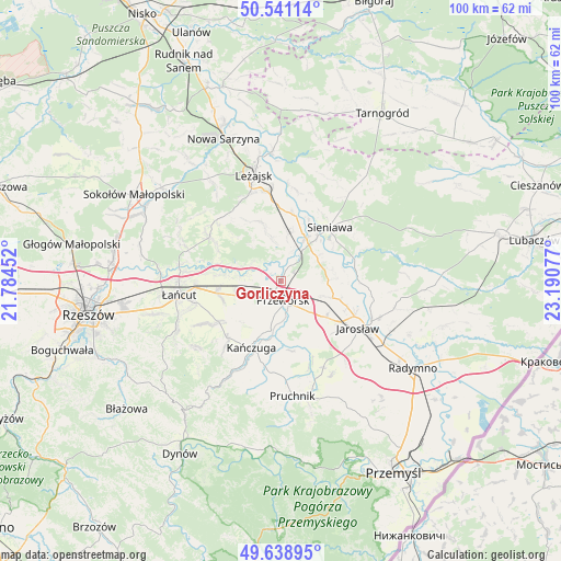
Gorliczyna GPS coordinates[2]
50° 5' 31.812" North, 22° 29' 15.504" East
| Map corner | latitude | longitude |
|---|---|---|
| Upper-left | 50.54114°, | 21.78452° |
| Center: | 50.09217°, | 22.48764° |
| Lower-right: | 49.63895°, | 23.19077° |
| Map W x H: | 100.3×100.3 km | = 62.3×62.3mi |
| max Lat: | 54.83135° ⇑78.4% North |
| Gorliczyna: | 50.09217° |
| min Lat: | ⇓21.6% South 49.21328° |
| min Long | Gorliczyna | max Long |
| 14.20249° | 22.48764° | 24.03723° |
| W 91.4%⇐ | ⇒8.6% E |
Elevation
Elevation of Gorliczyna is 179 m = 587 ft, and this is 12.4 m = 41 ft below average elevation for this country.
| Max E: |
974 m = 3196 ft | 47.4% |
| Avg. | 191.4 m = 628 ft | |
| Gorliczyna | 179 m = 587 ft | |
Min E: |
-3 m = -10 ft | 52.6% |
See also: Poland elevation on elevation.city.
Geographical zone
Gorliczyna is located in North temperate zone (between Tropic of Cancer and the Arctic Circle). Distance of this North polar circle is 1831.4 km =1138 mi to North.| Distance of | km | miles | from Gorliczyna |
|---|---|---|---|
| North Pole | 4437.3 | 2757.2 | to North |
| Arctic Circle | 1831.4 | 1138 | to North |
| Tropic Cancer | 2963.8 | 1841.6 | to South |
| Equator | 5569.7 | 3460.9 | to South |


Nearby cities:
15 places around Gorliczyna: (largest is in red/bold)
• Dębów
6.4 km =4 mi,  214°
214°
• Gorzyce
7.7 km =4.8 mi,  58°
58°
• Grodzisko Dolne
8 km =5 mi,  347°
347°
• Grzęska
2.6 km =1.6 mi,  247°
247°
• Jagiełła
6.1 km =3.8 mi,  87°
87°
• Maćkówka
7.3 km =4.5 mi,  163°
163°
• Mirocin
7.4 km =4.6 mi,  138°
138°
• Nowosielce
6.7 km =4.2 mi,  234°
234°
• Przeworsk
3.7 km =2.3 mi,  172°
172°
• Rogóźno
8.3 km =5.2 mi,  255°
255°
• Rozbórz
5.8 km =3.6 mi,  133°
133°
• Tryńcza
8.8 km =5.5 mi,  30°
30°
• Ujezna
7.8 km =4.8 mi,  110°
110°
• Urzejowice
9.1 km =5.7 mi,  191°
191°
• Żurawiczki
8.8 km =5.5 mi, 174°
Sources, notices
• [Note1] Compared only with cities in Poland existing in our database
• [Src1] Map data: © OpenStreetMap contributors (CC-BY-SA)
• [Src2] Other city data from geonames.org with taken over terms of usage.
• [Src3] Geographical zone / Annual Mean Temperature by Robert A. Rohde @ Wikipedia
