Mirocin geodata
Mirocin (Subcarpathian) is a populated place; located in Poland in Europe/Warsaw (GMT+2) time zone. With population of 1,405 people, there are 1950 cities with bigger population in this country. Compared to other cities in Poland, 80.5% of cities are located further ↑North; 92.3% of cities are located further ←West and 61.9% of cities have lower elevation than Mirocin. Note1


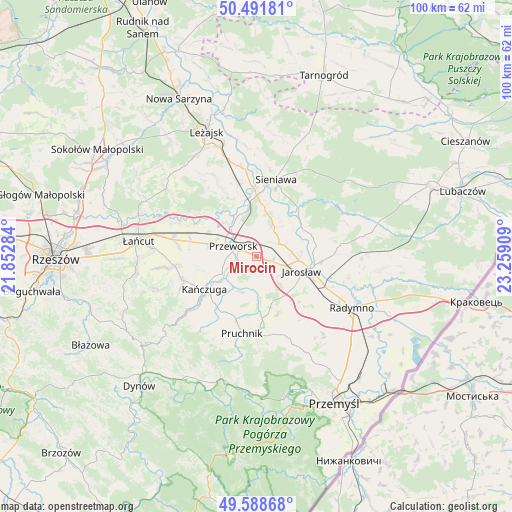
Mirocin GPS coordinates[2]
50° 2' 32.532" North, 22° 33' 21.456" East
| Map corner | latitude | longitude |
|---|---|---|
| Upper-left | 50.49181°, | 21.85284° |
| Center: | 50.04237°, | 22.55596° |
| Lower-right: | 49.58868°, | 23.25909° |
| Map W x H: | 100.4×100.4 km | = 62.4×62.4mi |
| max Lat: | 54.83135° ⇑80.5% North |
| Mirocin: | 50.04237° |
| min Lat: | ⇓19.5% South 49.21328° |
| min Long | Mirocin | max Long |
| 14.20249° | 22.55596° | 24.03723° |
| W 92.3%⇐ | ⇒7.7% E |
Elevation
Elevation of Mirocin is 205 m = 673 ft, and this is 13.6 m = 45 ft above average elevation for this country.
| Max E: |
974 m = 3196 ft | 38.1% |
| Mirocin | 205 m 673 ft | |
| Avg. | 191.4 m = 628 ft | |
Min E: |
-3 m = -10 ft | 61.9% |
See also: Poland elevation on elevation.city.
Geographical zone
Mirocin is located in North temperate zone (between Tropic of Cancer and the Arctic Circle). Distance of this North polar circle is 1837 km =1141.5 mi to North.| Distance of | km | miles | from Mirocin |
|---|---|---|---|
| North Pole | 4442.9 | 2760.7 | to North |
| Arctic Circle | 1837 | 1141.5 | to North |
| Tropic Cancer | 2958.3 | 1838.2 | to South |
| Equator | 5564.2 | 3457.4 | to South |


Nearby cities:
15 places around Mirocin: (largest is in red/bold)
• Cieszacin Wielki
6 km =3.7 mi,  153°
153°
• Gorliczyna
7.4 km =4.6 mi,  318°
318°
• Jagiełła
5.9 km =3.7 mi,  11°
11°
• Maćkówka
3.1 km =1.9 mi,  243°
243°
• Pawłosiów
8.4 km =5.2 mi,  128°
128°
• Przeworsk
4.8 km =3 mi,  292°
292°
• Rozbórz
1.7 km =1.1 mi,  337°
337°
• Rożniatów
7.7 km =4.8 mi,  202°
202°
• Ujezna
3.7 km =2.3 mi,  40°
40°
• Urzejowice
7.5 km =4.7 mi, 243°
• Wierzbna
3.4 km =2.1 mi,  107°
107°
• Wólka Pełkińska
7.6 km =4.7 mi, 39°
• Zalesie
3.7 km =2.3 mi,  206°
206°
• Zarzecze
6.4 km =4 mi,  192°
192°
• Żurawiczki
5.1 km =3.2 mi,  231°
231°
Sources, notices
• [Note1] Compared only with cities in Poland existing in our database
• [Src1] Map data: © OpenStreetMap contributors (CC-BY-SA)
• [Src2] Other city data from geonames.org with taken over terms of usage.
• [Src3] Geographical zone / Annual Mean Temperature by Robert A. Rohde @ Wikipedia
