Zarzecze geodata
Zarzecze (Subcarpathian) is a seat of a third-order administrative division; located in Poland in Europe/Warsaw (GMT+2) time zone. With population of 1,589 people, there are 1781 cities with bigger population in this country. Compared to other cities in Poland, 83.3% of cities are located further ↑North; 92.1% of cities are located further ←West and 60.3% of cities have lower elevation than Zarzecze. Note1


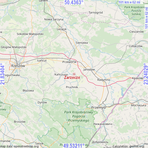
Zarzecze GPS coordinates[2]
49° 59' 10.788" North, 22° 32' 13.776" East
| Map corner | latitude | longitude |
|---|---|---|
| Upper-left | 50.4363°, | 21.83404° |
| Center: | 49.98633°, | 22.53716° |
| Lower-right: | 49.53211°, | 23.24029° |
| Map W x H: | 100.5×100.5 km | = 62.4×62.4mi |
| max Lat: | 54.83135° ⇑83.3% North |
| Zarzecze: | 49.98633° |
| min Lat: | ⇓16.7% South 49.21328° |
| min Long | Zarzecze | max Long |
| 14.20249° | 22.53716° | 24.03723° |
| W 92.1%⇐ | ⇒7.9% E |
Elevation
Elevation of Zarzecze is 201 m = 659 ft, and this is 9.6 m = 31 ft above average elevation for this country.
| Max E: |
974 m = 3196 ft | 39.7% |
| Zarzecze | 201 m 659 ft | |
| Avg. | 191.4 m = 628 ft | |
Min E: |
-3 m = -10 ft | 60.3% |
See also: Poland elevation on elevation.city.
Geographical zone
Zarzecze is located in North temperate zone (between Tropic of Cancer and the Arctic Circle). Distance of this North polar circle is 1843.2 km =1145.3 mi to North.| Distance of | km | miles | from Zarzecze |
|---|---|---|---|
| North Pole | 4449.1 | 2764.5 | to North |
| Arctic Circle | 1843.2 | 1145.3 | to North |
| Tropic Cancer | 2952 | 1834.3 | to South |
| Equator | 5558 | 3453.6 | to South |


Nearby cities:
15 places around Zarzecze: (largest is in red/bold)
• Cieszacin Wielki
4.1 km =2.5 mi,  78°
78°
• Jankowice
8.3 km =5.2 mi,  108°
108°
• Krzeczowice
5.3 km =3.3 mi,  273°
273°
• Maćkówka
5 km =3.1 mi,  343°
343°
• Mirocin
6.4 km =4 mi,  12°
12°
• Pantalowice
8.2 km =5.1 mi,  242°
242°
• Pawłosiów
8 km =5 mi, 82°
• Przeworsk
8.7 km =5.4 mi, 339°
• Rozbórz
7.8 km =4.8 mi, 5°
• Rożniatów
1.8 km =1.1 mi, 240°
• Rożwienica
5.5 km =3.4 mi,  132°
132°
• Urzejowice
6.1 km =3.8 mi,  297°
297°
• Wierzbna
6.9 km =4.3 mi,  41°
41°
• Zalesie
2.9 km =1.8 mi,  353°
353°
• Żurawiczki
4.1 km =2.5 mi,  318°
318°
Sources, notices
• [Note1] Compared only with cities in Poland existing in our database
• [Src1] Map data: © OpenStreetMap contributors (CC-BY-SA)
• [Src2] Other city data from geonames.org with taken over terms of usage.
• [Src3] Geographical zone / Annual Mean Temperature by Robert A. Rohde @ Wikipedia
