Ruszelczyce geodata
Ruszelczyce (Subcarpathian) is a populated place; located in Poland in Europe/Warsaw (GMT+2) time zone. With population of 556 people, there are 3396 cities with bigger population in this country. Compared to other cities in Poland, 91.4% of cities are located further ↑North; 92% of cities are located further ←West and 66.7% of cities have lower elevation than Ruszelczyce. Note1


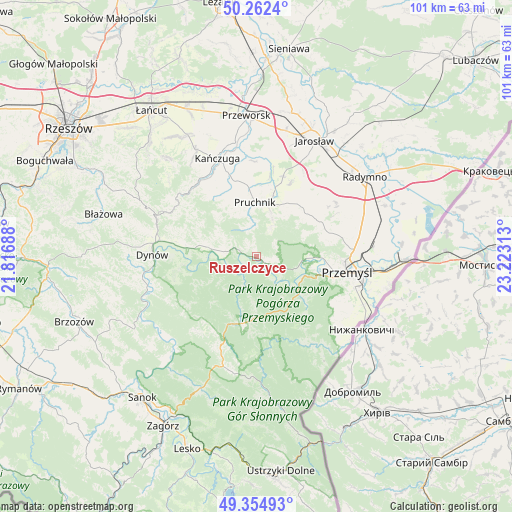
Ruszelczyce GPS coordinates[2]
49° 48' 38.844" North, 22° 31' 12" East
| Map corner | latitude | longitude |
|---|---|---|
| Upper-left | 50.2624°, | 21.81688° |
| Center: | 49.81079°, | 22.52° |
| Lower-right: | 49.35493°, | 23.22313° |
| Map W x H: | 100.9×100.9 km | = 62.7×62.7mi |
| max Lat: | 54.83135° ⇑91.4% North |
| Ruszelczyce: | 49.81079° |
| min Lat: | ⇓8.6% South 49.21328° |
| min Long | Ruszelczyce | max Long |
| 14.20249° | 22.52° | 24.03723° |
| W 92%⇐ | ⇒8% E |
Elevation
Elevation of Ruszelczyce is 219 m = 719 ft, and this is 27.6 m = 91 ft above average elevation for this country.
| Max E: |
974 m = 3196 ft | 33.3% |
| Ruszelczyce | 219 m 719 ft | |
| Avg. | 191.4 m = 628 ft | |
Min E: |
-3 m = -10 ft | 66.7% |
See also: Poland elevation on elevation.city.
Geographical zone
Ruszelczyce is located in North temperate zone (between Tropic of Cancer and the Arctic Circle). Distance of this North polar circle is 1862.7 km =1157.4 mi to North.| Distance of | km | miles | from Ruszelczyce |
|---|---|---|---|
| North Pole | 4468.6 | 2776.7 | to North |
| Arctic Circle | 1862.7 | 1157.4 | to North |
| Tropic Cancer | 2932.5 | 1822.2 | to South |
| Equator | 5538.4 | 3441.4 | to South |


Nearby cities:
15 places around Ruszelczyce: (largest is in red/bold)
• Babice
3.3 km =2.1 mi,  284°
284°
• Drohobyczka
12.9 km =8 mi,  293°
293°
• Dubiecko
9.4 km =5.8 mi, 280°
• Hucisko Nienadowskie
10.4 km =6.5 mi,  315°
315°
• Jodłówka
10 km =6.2 mi,  337°
337°
• Kramarzówka
5.7 km =3.5 mi,  346°
346°
• Krasiczyn
10.3 km =6.4 mi,  111°
111°
• Krzywcza
2.3 km =1.4 mi,  125°
125°
• Nienadowa
7 km =4.3 mi, 286°
• Pruchnik
10.6 km =6.6 mi,  358°
358°
• Przedmieście Dubieckie
11 km =6.8 mi, 285°
• Rokietnica
13.2 km =8.2 mi,  41°
41°
• Węgierka
9.1 km =5.7 mi,  18°
18°
• Śliwnica
9.2 km =5.7 mi,  303°
303°
• Świebodna
11.6 km =7.2 mi,  331°
331°
Sources, notices
• [Note1] Compared only with cities in Poland existing in our database
• [Src1] Map data: © OpenStreetMap contributors (CC-BY-SA)
• [Src2] Other city data from geonames.org with taken over terms of usage.
• [Src3] Geographical zone / Annual Mean Temperature by Robert A. Rohde @ Wikipedia
