Krzywcza geodata
Krzywcza (Subcarpathian) is a seat of a third-order administrative division; located in Poland in Europe/Warsaw (GMT+2) time zone. With population of 600 people, there are 3270 cities with bigger population in this country. Compared to other cities in Poland, 91.8% of cities are located further ↑North; 92.2% of cities are located further ←West and 71.6% of cities have lower elevation than Krzywcza. Note1


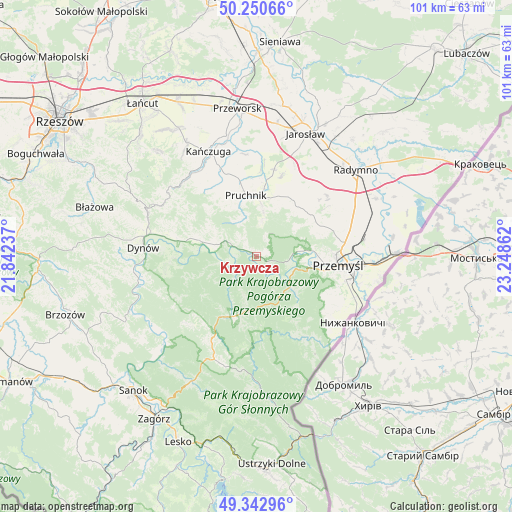
Krzywcza GPS coordinates[2]
49° 47' 56.184" North, 22° 32' 43.764" East
| Map corner | latitude | longitude |
|---|---|---|
| Upper-left | 50.25066°, | 21.84237° |
| Center: | 49.79894°, | 22.54549° |
| Lower-right: | 49.34296°, | 23.24862° |
| Map W x H: | 100.9×100.9 km | = 62.7×62.7mi |
| max Lat: | 54.83135° ⇑91.8% North |
| Krzywcza: | 49.79894° |
| min Lat: | ⇓8.2% South 49.21328° |
| min Long | Krzywcza | max Long |
| 14.20249° | 22.54549° | 24.03723° |
| W 92.2%⇐ | ⇒7.8% E |
Elevation
Elevation of Krzywcza is 234 m = 768 ft, and this is 42.6 m = 140 ft above average elevation for this country.
| Max E: |
974 m = 3196 ft | 28.4% |
| Krzywcza | 234 m 768 ft | |
| Avg. | 191.4 m = 628 ft | |
Min E: |
-3 m = -10 ft | 71.6% |
See also: Poland elevation on elevation.city.
Geographical zone
Krzywcza is located in North temperate zone (between Tropic of Cancer and the Arctic Circle). Distance of this North polar circle is 1864.1 km =1158.3 mi to North.| Distance of | km | miles | from Krzywcza |
|---|---|---|---|
| North Pole | 4469.9 | 2777.5 | to North |
| Arctic Circle | 1864.1 | 1158.3 | to North |
| Tropic Cancer | 2931.2 | 1821.4 | to South |
| Equator | 5537.1 | 3440.6 | to South |


Nearby cities:
15 places around Krzywcza: (largest is in red/bold)
• Babice
5.4 km =3.4 mi,  293°
293°
• Bircza
12.9 km =8 mi,  201°
201°
• Dubiecko
11.5 km =7.1 mi, 285°
• Hucisko Nienadowskie
12.6 km =7.8 mi,  313°
313°
• Jodłówka
12 km =7.5 mi,  331°
331°
• Kramarzówka
7.5 km =4.7 mi,  335°
335°
• Krasiczyn
8.1 km =5 mi,  108°
108°
• Nienadowa
9.1 km =5.7 mi, 291°
• Pruchnik
12.1 km =7.5 mi,  349°
349°
• Przedmieście Dubieckie
13.2 km =8.2 mi, 288°
• Rokietnica
13.2 km =8.2 mi,  31°
31°
• Ruszelczyce
2.3 km =1.4 mi, 305°
• Węgierka
10 km =6.2 mi,  5°
5°
• Śliwnica
11.4 km =7.1 mi,  303°
303°
• Świebodna
13.7 km =8.5 mi, 327°
Sources, notices
• [Note1] Compared only with cities in Poland existing in our database
• [Src1] Map data: © OpenStreetMap contributors (CC-BY-SA)
• [Src2] Other city data from geonames.org with taken over terms of usage.
• [Src3] Geographical zone / Annual Mean Temperature by Robert A. Rohde @ Wikipedia
