Pruchnik geodata
Pruchnik (Subcarpathian) is a populated place; located in Poland in Europe/Warsaw (GMT+2) time zone. With population of 3,694 people, there are 878 cities with bigger population in this country. Compared to other cities in Poland, 87.2% of cities are located further ↑North; 91.8% of cities are located further ←West and 74.6% of cities have lower elevation than Pruchnik. Note1


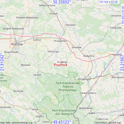
Pruchnik GPS coordinates[2]
49° 54' 22.32" North, 22° 30' 55.944" East
| Map corner | latitude | longitude |
|---|---|---|
| Upper-left | 50.35692°, | 21.81242° |
| Center: | 49.9062°, | 22.51554° |
| Lower-right: | 49.45123°, | 23.21867° |
| Map W x H: | 100.7×100.7 km | = 62.6×62.6mi |
| max Lat: | 54.83135° ⇑87.2% North |
| Pruchnik: | 49.9062° |
| min Lat: | ⇓12.8% South 49.21328° |
| min Long | Pruchnik | max Long |
| 14.20249° | 22.51554° | 24.03723° |
| W 91.8%⇐ | ⇒8.2% E |
Elevation
Elevation of Pruchnik is 245 m = 804 ft, and this is 53.6 m = 176 ft above average elevation for this country.
| Max E: |
974 m = 3196 ft | 25.4% |
| Pruchnik | 245 m 804 ft | |
| Avg. | 191.4 m = 628 ft | |
Min E: |
-3 m = -10 ft | 74.6% |
See also: Poland elevation on elevation.city.
Geographical zone
Pruchnik is located in North temperate zone (between Tropic of Cancer and the Arctic Circle). Distance of this North polar circle is 1852.1 km =1150.8 mi to North.| Distance of | km | miles | from Pruchnik |
|---|---|---|---|
| North Pole | 4458 | 2770.1 | to North |
| Arctic Circle | 1852.1 | 1150.8 | to North |
| Tropic Cancer | 2943.1 | 1828.8 | to South |
| Equator | 5549 | 3448 | to South |


Nearby cities:
15 places around Pruchnik: (largest is in red/bold)
• Babice
10.2 km =6.3 mi,  196°
196°
• Hucisko Nienadowskie
7.7 km =4.8 mi,  245°
245°
• Jodłówka
3.8 km =2.4 mi, 249°
• Kramarzówka
5.2 km =3.2 mi,  191°
191°
• Krzeczowice
9.9 km =6.2 mi,  338°
338°
• Pantalowice
7.7 km =4.8 mi,  311°
311°
• Rokietnica
9.1 km =5.7 mi,  94°
94°
• Rożniatów
8 km =5 mi,  359°
359°
• Rożwienica
7.7 km =4.8 mi,  47°
47°
• Ruszelczyce
10.6 km =6.6 mi,  178°
178°
• Węgierka
3.7 km =2.3 mi,  121°
121°
• Zarzecze
9 km =5.6 mi,  9°
9°
• Łopuszka Wielka
9.3 km =5.8 mi,  289°
289°
• Śliwnica
9.2 km =5.7 mi,  232°
232°
• Świebodna
5.2 km =3.2 mi,  266°
266°
Sources, notices
• [Note1] Compared only with cities in Poland existing in our database
• [Src1] Map data: © OpenStreetMap contributors (CC-BY-SA)
• [Src2] Other city data from geonames.org with taken over terms of usage.
• [Src3] Geographical zone / Annual Mean Temperature by Robert A. Rohde @ Wikipedia
