Pantalowice geodata
Pantalowice (Subcarpathian) is a populated place; located in Poland in Europe/Warsaw (GMT+1) time zone. With population of 1,242 people, there are 2136 cities with bigger population in this country. Compared to other cities in Poland, 85.3% of cities are located further ↑North; 90.7% of cities are located further ←West and 67.1% of cities have lower elevation than Pantalowice. Note1


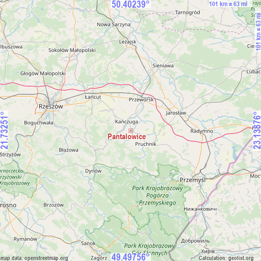
Pantalowice GPS coordinates[2]
49° 57' 7.56" North, 22° 26' 8.268" East
| Map corner | latitude | longitude |
|---|---|---|
| Upper-left | 50.40239°, | 21.73251° |
| Center: | 49.9521°, | 22.43563° |
| Lower-right: | 49.49756°, | 23.13876° |
| Map W x H: | 100.6×100.6 km | = 62.5×62.5mi |
| max Lat: | 54.83135° ⇑85.3% North |
| Pantalowice: | 49.9521° |
| min Lat: | ⇓14.7% South 49.21328° |
| min Long | Pantalowice | max Long |
| 14.20249° | 22.43563° | 24.03723° |
| W 90.7%⇐ | ⇒9.3% E |
Elevation
Elevation of Pantalowice is 220 m = 722 ft, and this is 28.6 m = 94 ft above average elevation for this country.
| Max E: |
974 m = 3196 ft | 32.9% |
| Pantalowice | 220 m 722 ft | |
| Avg. | 191.4 m = 628 ft | |
Min E: |
-3 m = -10 ft | 67.1% |
See also: Poland elevation on elevation.city.
Geographical zone
Pantalowice is located in North temperate zone (between Tropic of Cancer and the Arctic Circle). Distance of this North polar circle is 1847 km =1147.7 mi to North.| Distance of | km | miles | from Pantalowice |
|---|---|---|---|
| North Pole | 4452.9 | 2766.9 | to North |
| Arctic Circle | 1847 | 1147.7 | to North |
| Tropic Cancer | 2948.2 | 1831.9 | to South |
| Equator | 5554.2 | 3451.2 | to South |


Nearby cities:
15 places around Pantalowice: (largest is in red/bold)
• Hucisko Nienadowskie
8.4 km =5.2 mi,  188°
188°
• Jodłówka
6.8 km =4.2 mi,  161°
161°
• Kańczuga
3.9 km =2.4 mi,  333°
333°
• Krzeczowice
4.6 km =2.9 mi,  26°
26°
• Manasterz
6.7 km =4.2 mi,  253°
253°
• Pruchnik
7.7 km =4.8 mi,  131°
131°
• Rożniatów
6.4 km =4 mi,  62°
62°
• Siedleczka
4.1 km =2.5 mi,  283°
283°
• Sietesz
7.4 km =4.6 mi,  300°
300°
• Urzejowice
6.9 km =4.3 mi,  15°
15°
• Zalesie
9.6 km =6 mi,  46°
46°
• Zarzecze
8.2 km =5.1 mi, 62°
• Łopuszka Wielka
3.6 km =2.2 mi,  237°
237°
• Świebodna
5.5 km =3.4 mi,  174°
174°
• Żurawiczki
8.2 km =5.1 mi, 33°
Sources, notices
• [Note1] Compared only with cities in Poland existing in our database
• [Src1] Map data: © OpenStreetMap contributors (CC-BY-SA)
• [Src2] Other city data from geonames.org with taken over terms of usage.
• [Src3] Geographical zone / Annual Mean Temperature by Robert A. Rohde @ Wikipedia
