Rożniatów geodata
Rożniatów (Subcarpathian) is a populated place; located in Poland in Europe/Warsaw (GMT+2) time zone. With population of 681 people, there are 3109 cities with bigger population in this country. Compared to other cities in Poland, 84% of cities are located further ↑North; 91.8% of cities are located further ←West and 58.8% of cities have lower elevation than Rożniatów. Note1


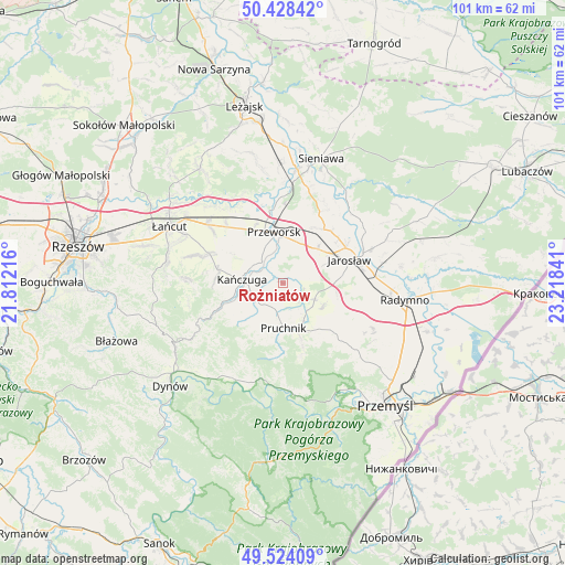
Rożniatów GPS coordinates[2]
49° 58' 42.168" North, 22° 30' 55.008" East
| Map corner | latitude | longitude |
|---|---|---|
| Upper-left | 50.42842°, | 21.81216° |
| Center: | 49.97838°, | 22.51528° |
| Lower-right: | 49.52409°, | 23.21841° |
| Map W x H: | 100.6×100.6 km | = 62.5×62.5mi |
| max Lat: | 54.83135° ⇑84% North |
| Rożniatów: | 49.97838° |
| min Lat: | ⇓16% South 49.21328° |
| min Long | Rożniatów | max Long |
| 14.20249° | 22.51528° | 24.03723° |
| W 91.8%⇐ | ⇒8.2% E |
Elevation
Elevation of Rożniatów is 196 m = 643 ft, and this is 4.6 m = 15 ft above average elevation for this country.
| Max E: |
974 m = 3196 ft | 41.2% |
| Rożniatów | 196 m 643 ft | |
| Avg. | 191.4 m = 628 ft | |
Min E: |
-3 m = -10 ft | 58.8% |
See also: Poland elevation on elevation.city.
Geographical zone
Rożniatów is located in North temperate zone (between Tropic of Cancer and the Arctic Circle). Distance of this North polar circle is 1844.1 km =1145.9 mi to North.| Distance of | km | miles | from Rożniatów |
|---|---|---|---|
| North Pole | 4450 | 2765.1 | to North |
| Arctic Circle | 1844.1 | 1145.9 | to North |
| Tropic Cancer | 2951.2 | 1833.8 | to South |
| Equator | 5557.1 | 3453 | to South |


Nearby cities:
15 places around Rożniatów: (largest is in red/bold)
• Cieszacin Wielki
5.9 km =3.7 mi,  72°
72°
• Kańczuga
7.4 km =4.6 mi,  274°
274°
• Krzeczowice
3.9 km =2.4 mi,  288°
288°
• Maćkówka
5.7 km =3.5 mi,  0°
0°
• Mirocin
7.7 km =4.8 mi,  22°
22°
• Pantalowice
6.4 km =4 mi,  242°
242°
• Pruchnik
8 km =5 mi,  179°
179°
• Przeworsk
9.1 km =5.7 mi,  350°
350°
• Rozbórz
8.9 km =5.5 mi,  14°
14°
• Rożwienica
6.3 km =3.9 mi,  116°
116°
• Urzejowice
5.3 km =3.3 mi,  314°
314°
• Wierzbna
8.6 km =5.3 mi,  45°
45°
• Zalesie
4 km =2.5 mi, 18°
• Zarzecze
1.8 km =1.1 mi,  60°
60°
• Żurawiczki
4.1 km =2.5 mi,  343°
343°
Sources, notices
• [Note1] Compared only with cities in Poland existing in our database
• [Src1] Map data: © OpenStreetMap contributors (CC-BY-SA)
• [Src2] Other city data from geonames.org with taken over terms of usage.
• [Src3] Geographical zone / Annual Mean Temperature by Robert A. Rohde @ Wikipedia
