Józefów geodata
Józefów (Mazovia) is a populated place; located in Poland in Europe/Warsaw (GMT+2) time zone. With population of 1,766 people, there are 1643 cities with bigger population in this country. Compared to other cities in Poland, 69.9% of cities are located further ↓South; 67.6% of cities are located further ←West and 86.1% of cities have higher elevation than Józefów. Note1
Administrative division(s):
- Level 1: Mazovia
- Level 2: Powiat warszawski zachodni
- Level 3: Ożarów Mazowiecki


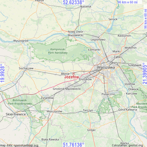
Józefów GPS coordinates[2]
52° 11' 40.056" North, 20° 41' 45.312" East
| Map corner | latitude | longitude |
|---|---|---|
| Upper-left | 52.62338°, | 19.9928° |
| Center: | 52.19446°, | 20.69592° |
| Lower-right: | 51.76136°, | 21.39905° |
| Map W x H: | 95.8×95.8 km | = 59.5×59.5mi |
| max Lat: | 54.83135° ⇑30.1% North |
| Józefów: | 52.19446° |
| min Lat: | ⇓69.9% South 49.21328° |
| min Long | Józefów | max Long |
| 14.20249° | 20.69592° | 24.03723° |
| W 67.6%⇐ | ⇒32.4% E |
Elevation
Elevation of Józefów is 87 m = 285 ft, and this is 104.4 m = 343 ft below average elevation for this country.
| Max E: |
974 m = 3196 ft | 86.1% |
| Avg. | 191.4 m = 628 ft | |
| Józefów | 87 m = 285 ft | |
Min E: |
-3 m = -10 ft | 13.9% |
See also: Poland elevation on elevation.city.
Geographical zone
Józefów is located in North temperate zone (between Tropic of Cancer and the Arctic Circle). Distance of this North polar circle is 1597.7 km =992.8 mi to North.| Distance of | km | miles | from Józefów |
|---|---|---|---|
| North Pole | 4203.6 | 2612 | to North |
| Arctic Circle | 1597.7 | 992.8 | to North |
| Tropic Cancer | 3197.6 | 1986.9 | to South |
| Equator | 5803.5 | 3606.1 | to South |


Nearby cities:
15 places around Józefów: (largest is in red/bold)
• Bieniewice
9.2 km =5.7 mi,  261°
261°
• Brwinów
5.9 km =3.7 mi,  165°
165°
• Błonie
5.4 km =3.4 mi,  274°
274°
• Duchnice
7.1 km =4.4 mi,  83°
83°
• Kanie
8 km =5 mi,  141°
141°
• Komorów
9.8 km =6.1 mi,  123°
123°
• Milanówek
8.6 km =5.3 mi,  191°
191°
• Otrębusy
8.6 km =5.3 mi,  148°
148°
• Owczarnia
9.3 km =5.8 mi,  176°
176°
• Ołtarzew
4.7 km =2.9 mi,  65°
65°
• Ożarów Mazowiecki
7.1 km =4.4 mi, 75°
• Piastów
9.9 km =6.2 mi,  96°
96°
• Podkowa Leśna
8.3 km =5.2 mi, 165°
• Pruszków
8.4 km =5.2 mi,  108°
108°
• Zaborów
7.7 km =4.8 mi,  350°
350°
Sources, notices
• [Note1] Compared only with cities in Poland existing in our database
• [Src1] Map data: © OpenStreetMap contributors (CC-BY-SA)
• [Src2] Other city data from geonames.org with taken over terms of usage.
• [Src3] Geographical zone / Annual Mean Temperature by Robert A. Rohde @ Wikipedia
