Niedźwiada geodata
Niedźwiada (Lublin) is a seat of a third-order administrative division; located in Poland in Europe/Warsaw (GMT+2) time zone. With population of 754 people, there are 2942 cities with bigger population in this country. Compared to other cities in Poland, 57% of cities are located further ↓South; 93.7% of cities are located further ←West and 54.2% of cities have higher elevation than Niedźwiada. Note1


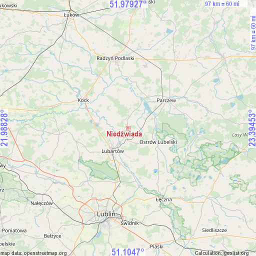
Niedźwiada GPS coordinates[2]
51° 32' 38.724" North, 22° 41' 29.04" East
| Map corner | latitude | longitude |
|---|---|---|
| Upper-left | 51.97927°, | 21.98828° |
| Center: | 51.54409°, | 22.6914° |
| Lower-right: | 51.1047°, | 23.39453° |
| Map W x H: | 97.2×97.2 km | = 60.4×60.4mi |
| max Lat: | 54.83135° ⇑43% North |
| Niedźwiada: | 51.54409° |
| min Lat: | ⇓57% South 49.21328° |
| min Long | Niedźwiada | max Long |
| 14.20249° | 22.6914° | 24.03723° |
| W 93.7%⇐ | ⇒6.3% E |
Elevation
Elevation of Niedźwiada is 161 m = 528 ft, and this is 30.4 m = 100 ft below average elevation for this country.
| Max E: |
974 m = 3196 ft | 54.2% |
| Avg. | 191.4 m = 628 ft | |
| Niedźwiada | 161 m = 528 ft | |
Min E: |
-3 m = -10 ft | 45.8% |
See also: Poland elevation on elevation.city.
Geographical zone
Niedźwiada is located in North temperate zone (between Tropic of Cancer and the Arctic Circle). Distance of this North polar circle is 1670 km =1037.7 mi to North.| Distance of | km | miles | from Niedźwiada |
|---|---|---|---|
| North Pole | 4275.9 | 2656.9 | to North |
| Arctic Circle | 1670 | 1037.7 | to North |
| Tropic Cancer | 3125.2 | 1941.9 | to South |
| Equator | 5731.2 | 3561.2 | to South |


Nearby cities:
15 places around Niedźwiada: (largest is in red/bold)
• Brzeźnica Bychawska
4.5 km =2.8 mi,  113°
113°
• Czemierniki
14.8 km =9.2 mi,  345°
345°
• Firlej
12.8 km =8 mi,  277°
277°
• Kamionka
17.8 km =11.1 mi,  243°
243°
• Kozłówka
17.1 km =10.6 mi,  231°
231°
• Lubartów
10.9 km =6.8 mi,  211°
211°
• Ostrów Lubelski
12.5 km =7.8 mi,  116°
116°
• Ostrówek
6.9 km =4.3 mi,  307°
307°
• Parczew
18 km =11.2 mi,  53°
53°
• Pałecznica
6.9 km =4.3 mi,  190°
190°
• Serniki
12.1 km =7.5 mi, 190°
• Siemień
11 km =6.8 mi,  30°
30°
• Uścimów Nowy
18.4 km =11.4 mi, 119°
• Uścimów Stary
20 km =12.4 mi, 114°
• Wola Sernicka
10.5 km =6.5 mi,  182°
182°
Sources, notices
• [Note1] Compared only with cities in Poland existing in our database
• [Src1] Map data: © OpenStreetMap contributors (CC-BY-SA)
• [Src2] Other city data from geonames.org with taken over terms of usage.
• [Src3] Geographical zone / Annual Mean Temperature by Robert A. Rohde @ Wikipedia
