Siemień geodata
Siemień (Lublin) is a seat of a third-order administrative division; located in Poland in Europe/Warsaw (GMT+2) time zone. With population of 581 people, there are 3332 cities with bigger population in this country. Compared to other cities in Poland, 58.6% of cities are located further ↓South; 94.3% of cities are located further ←West and 62.1% of cities have higher elevation than Siemień. Note1


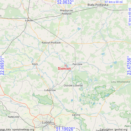
Siemień GPS coordinates[2]
51° 37' 43.788" North, 22° 46' 20.748" East
| Map corner | latitude | longitude |
|---|---|---|
| Upper-left | 52.0632°, | 22.06931° |
| Center: | 51.62883°, | 22.77243° |
| Lower-right: | 51.19026°, | 23.47556° |
| Map W x H: | 97.1×97.1 km | = 60.3×60.3mi |
| max Lat: | 54.83135° ⇑41.4% North |
| Siemień: | 51.62883° |
| min Lat: | ⇓58.6% South 49.21328° |
| min Long | Siemień | max Long |
| 14.20249° | 22.77243° | 24.03723° |
| W 94.3%⇐ | ⇒5.7% E |
Elevation
Elevation of Siemień is 142 m = 466 ft, and this is 49.4 m = 162 ft below average elevation for this country.
| Max E: |
974 m = 3196 ft | 62.1% |
| Avg. | 191.4 m = 628 ft | |
| Siemień | 142 m = 466 ft | |
Min E: |
-3 m = -10 ft | 37.9% |
See also: Poland elevation on elevation.city.
Geographical zone
Siemień is located in North temperate zone (between Tropic of Cancer and the Arctic Circle). Distance of this North polar circle is 1660.6 km =1031.8 mi to North.| Distance of | km | miles | from Siemień |
|---|---|---|---|
| North Pole | 4266.5 | 2651.1 | to North |
| Arctic Circle | 1660.6 | 1031.8 | to North |
| Tropic Cancer | 3134.7 | 1947.8 | to South |
| Equator | 5740.6 | 3567 | to South |


Nearby cities:
15 places around Siemień: (largest is in red/bold)
• Borki
20.2 km =12.6 mi,  300°
300°
• Brzeźnica Bychawska
11.3 km =7 mi,  187°
187°
• Czemierniki
10.4 km =6.5 mi, 298°
• Dębowa Kłoda
16.6 km =10.3 mi,  103°
103°
• Firlej
19.8 km =12.3 mi,  246°
246°
• Kostry
12.4 km =7.7 mi,  52°
52°
• Milanów
11.5 km =7.1 mi,  43°
43°
• Niedźwiada
11 km =6.8 mi,  210°
210°
• Ostrów Lubelski
16 km =9.9 mi,  159°
159°
• Ostrówek
12.2 km =7.6 mi,  244°
244°
• Parczew
8.9 km =5.5 mi,  81°
81°
• Pałecznica
17.6 km =10.9 mi,  202°
202°
• Radzyń Podlaski
20.3 km =12.6 mi,  328°
328°
• Wohyń
14.2 km =8.8 mi,  3°
3°
• Wola Sernicka
20.8 km =12.9 mi, 197°
Sources, notices
• [Note1] Compared only with cities in Poland existing in our database
• [Src1] Map data: © OpenStreetMap contributors (CC-BY-SA)
• [Src2] Other city data from geonames.org with taken over terms of usage.
• [Src3] Geographical zone / Annual Mean Temperature by Robert A. Rohde @ Wikipedia
