Niwiska geodata
Niwiska (Subcarpathian) is a populated place; located in Poland in Europe/Warsaw (GMT+2) time zone. With population of 1,560 people, there are 1796 cities with bigger population in this country. Compared to other cities in Poland, 73.9% of cities are located further ↑North; 80.5% of cities are located further ←West and 68.1% of cities have lower elevation than Niwiska. Note1


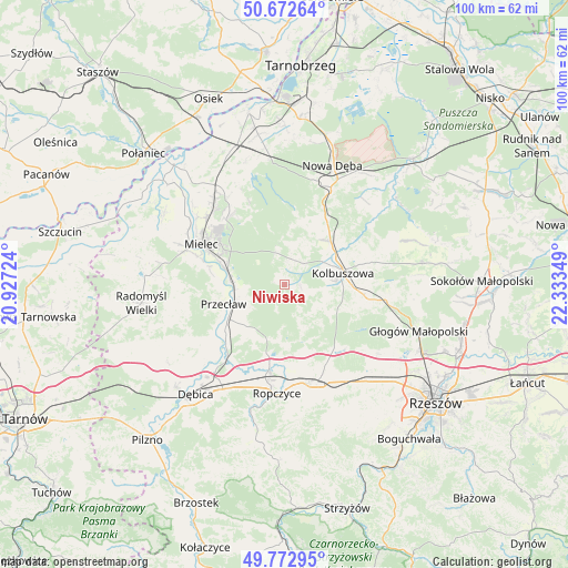
Niwiska GPS coordinates[2]
50° 13' 29.712" North, 21° 37' 49.296" East
| Map corner | latitude | longitude |
|---|---|---|
| Upper-left | 50.67264°, | 20.92724° |
| Center: | 50.22492°, | 21.63036° |
| Lower-right: | 49.77295°, | 22.33349° |
| Map W x H: | 100×100 km | = 62.1×62.1mi |
| max Lat: | 54.83135° ⇑73.9% North |
| Niwiska: | 50.22492° |
| min Lat: | ⇓26.1% South 49.21328° |
| min Long | Niwiska | max Long |
| 14.20249° | 21.63036° | 24.03723° |
| W 80.5%⇐ | ⇒19.5% E |
Elevation
Elevation of Niwiska is 223 m = 732 ft, and this is 31.6 m = 104 ft above average elevation for this country.
| Max E: |
974 m = 3196 ft | 31.9% |
| Niwiska | 223 m 732 ft | |
| Avg. | 191.4 m = 628 ft | |
Min E: |
-3 m = -10 ft | 68.1% |
See also: Poland elevation on elevation.city.
Geographical zone
Niwiska is located in North temperate zone (between Tropic of Cancer and the Arctic Circle). Distance of this North polar circle is 1816.7 km =1128.8 mi to North.| Distance of | km | miles | from Niwiska |
|---|---|---|---|
| North Pole | 4422.6 | 2748.1 | to North |
| Arctic Circle | 1816.7 | 1128.8 | to North |
| Tropic Cancer | 2978.6 | 1850.8 | to South |
| Equator | 5584.5 | 3470 | to South |


Nearby cities:
15 places around Niwiska: (largest is in red/bold)
• Brzeźnica
17.5 km =10.9 mi,  217°
217°
• Błonie
10.5 km =6.5 mi,  263°
263°
• Cmolas
11.3 km =7 mi,  45°
45°
• Dzikowiec
16.1 km =10 mi,  70°
70°
• Kolbuszowa
10.6 km =6.6 mi,  78°
78°
• Krzywa
15.7 km =9.8 mi,  151°
151°
• Mechowiec
14.6 km =9.1 mi,  62°
62°
• Mielec
16.2 km =10.1 mi,  295°
295°
• Ostrowy Baranowskie
12.7 km =7.9 mi,  8°
8°
• Ostrowy Tuszowskie
10.4 km =6.5 mi, 8°
• Ostrów
14.4 km =8.9 mi,  190°
190°
• Przecław
11.3 km =7 mi,  251°
251°
• Przyłęk
5.9 km =3.7 mi,  343°
343°
• Sędziszów Małopolski
17.9 km =11.1 mi,  163°
163°
• Trześń
3.1 km =1.9 mi,  92°
92°
Sources, notices
• [Note1] Compared only with cities in Poland existing in our database
• [Src1] Map data: © OpenStreetMap contributors (CC-BY-SA)
• [Src2] Other city data from geonames.org with taken over terms of usage.
• [Src3] Geographical zone / Annual Mean Temperature by Robert A. Rohde @ Wikipedia
