Mechowiec geodata
Mechowiec (Subcarpathian) is a populated place; located in Poland in Europe/Warsaw (GMT+2) time zone. With population of 598 people, there are 3292 cities with bigger population in this country. Compared to other cities in Poland, 72.4% of cities are located further ↑North; 82.4% of cities are located further ←West and 58.3% of cities have lower elevation than Mechowiec. Note1


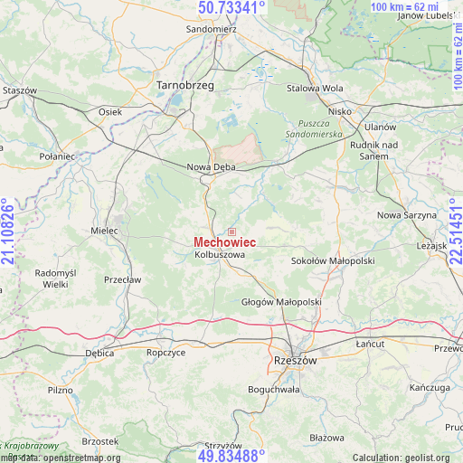
Mechowiec GPS coordinates[2]
50° 17' 10.572" North, 21° 48' 40.968" East
| Map corner | latitude | longitude |
|---|---|---|
| Upper-left | 50.73341°, | 21.10826° |
| Center: | 50.28627°, | 21.81138° |
| Lower-right: | 49.83488°, | 22.51451° |
| Map W x H: | 99.9×99.9 km | = 62.1×62.1mi |
| max Lat: | 54.83135° ⇑72.4% North |
| Mechowiec: | 50.28627° |
| min Lat: | ⇓27.6% South 49.21328° |
| min Long | Mechowiec | max Long |
| 14.20249° | 21.81138° | 24.03723° |
| W 82.4%⇐ | ⇒17.6% E |
Elevation
Elevation of Mechowiec is 194 m = 636 ft, and this is 2.6 m = 9 ft above average elevation for this country.
| Max E: |
974 m = 3196 ft | 41.7% |
| Mechowiec | 194 m 636 ft | |
| Avg. | 191.4 m = 628 ft | |
Min E: |
-3 m = -10 ft | 58.3% |
See also: Poland elevation on elevation.city.
Geographical zone
Mechowiec is located in North temperate zone (between Tropic of Cancer and the Arctic Circle). Distance of this North polar circle is 1809.9 km =1124.6 mi to North.| Distance of | km | miles | from Mechowiec |
|---|---|---|---|
| North Pole | 4415.8 | 2743.9 | to North |
| Arctic Circle | 1809.9 | 1124.6 | to North |
| Tropic Cancer | 2985.4 | 1855 | to South |
| Equator | 5591.3 | 3474.3 | to South |


Nearby cities:
15 places around Mechowiec: (largest is in red/bold)
• Bojanów
18.4 km =11.4 mi,  32°
32°
• Cmolas
4.9 km =3 mi,  281°
281°
• Dzikowiec
2.7 km =1.7 mi,  122°
122°
• Gwoździec
16.2 km =10.1 mi,  51°
51°
• Głogów Małopolski
18.5 km =11.5 mi,  144°
144°
• Kolbuszowa
5.3 km =3.3 mi,  208°
208°
• Lipnica
5.5 km =3.4 mi,  86°
86°
• Majdan Królewski
11.3 km =7 mi,  335°
335°
• Niwiska
14.6 km =9.1 mi,  242°
242°
• Nowa Dęba
16.5 km =10.3 mi, 344°
• Ostrowy Baranowskie
12.3 km =7.6 mi,  297°
297°
• Ostrowy Tuszowskie
11.9 km =7.4 mi,  287°
287°
• Przyłęk
14.6 km =9.1 mi,  265°
265°
• Raniżów
11.8 km =7.3 mi,  105°
105°
• Trześń
12 km =7.5 mi,  234°
234°
Sources, notices
• [Note1] Compared only with cities in Poland existing in our database
• [Src1] Map data: © OpenStreetMap contributors (CC-BY-SA)
• [Src2] Other city data from geonames.org with taken over terms of usage.
• [Src3] Geographical zone / Annual Mean Temperature by Robert A. Rohde @ Wikipedia
