Kolbuszowa geodata
Kolbuszowa (Subcarpathian) is a seat of a second-order administrative division; located in Poland in Europe/Warsaw (GMT+2) time zone. With population of 10,442 people, there are 432 cities with bigger population in this country. Compared to other cities in Poland, 73.3% of cities are located further ↑North; 82% of cities are located further ←West and 61% of cities have lower elevation than Kolbuszowa. Note1


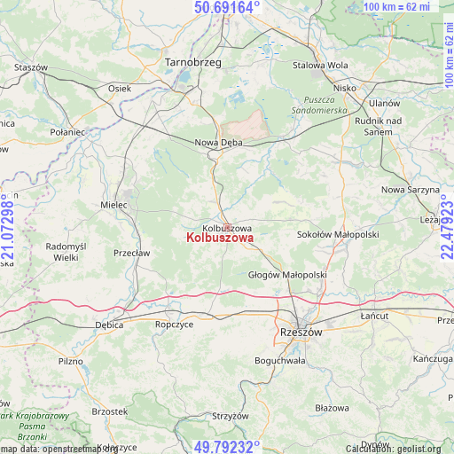
Kolbuszowa GPS coordinates[2]
50° 14' 38.76" North, 21° 46' 33.96" East
| Map corner | latitude | longitude |
|---|---|---|
| Upper-left | 50.69164°, | 21.07298° |
| Center: | 50.2441°, | 21.7761° |
| Lower-right: | 49.79232°, | 22.47923° |
| Map W x H: | 100×100 km | = 62.1×62.1mi |
| max Lat: | 54.83135° ⇑73.3% North |
| Kolbuszowa: | 50.2441° |
| min Lat: | ⇓26.7% South 49.21328° |
| min Long | Kolbuszowa | max Long |
| 14.20249° | 21.7761° | 24.03723° |
| W 82%⇐ | ⇒18% E |
Elevation
Elevation of Kolbuszowa is 203 m = 666 ft, and this is 11.6 m = 38 ft above average elevation for this country.
| Max E: |
974 m = 3196 ft | 39% |
| Kolbuszowa | 203 m 666 ft | |
| Avg. | 191.4 m = 628 ft | |
Min E: |
-3 m = -10 ft | 61% |
See also: Poland elevation on elevation.city.
Geographical zone
Kolbuszowa is located in North temperate zone (between Tropic of Cancer and the Arctic Circle). Distance of this North polar circle is 1814.6 km =1127.5 mi to North.| Distance of | km | miles | from Kolbuszowa |
|---|---|---|---|
| North Pole | 4420.4 | 2746.7 | to North |
| Arctic Circle | 1814.6 | 1127.5 | to North |
| Tropic Cancer | 2980.7 | 1852.1 | to South |
| Equator | 5586.6 | 3471.4 | to South |


Nearby cities:
15 places around Kolbuszowa: (largest is in red/bold)
• Cmolas
6.1 km =3.8 mi,  338°
338°
• Dzikowiec
5.8 km =3.6 mi,  56°
56°
• Głogów Małopolski
16.8 km =10.4 mi,  127°
127°
• Krzywa
16.2 km =10.1 mi,  190°
190°
• Lipnica
9.4 km =5.8 mi, 57°
• Majdan Królewski
15.2 km =9.4 mi,  351°
351°
• Mechowiec
5.3 km =3.3 mi,  28°
28°
• Niwiska
10.6 km =6.6 mi,  258°
258°
• Ostrowy Baranowskie
13.4 km =8.3 mi,  321°
321°
• Ostrowy Tuszowskie
12.1 km =7.5 mi,  312°
312°
• Przyłęk
12.6 km =7.8 mi,  286°
286°
• Raniżów
14 km =8.7 mi,  83°
83°
• Trzciana
19.7 km =12.2 mi,  166°
166°
• Trześń
7.7 km =4.8 mi,  252°
252°
• Wysoka Głogowska
19.8 km =12.3 mi,  118°
118°
Sources, notices
• [Note1] Compared only with cities in Poland existing in our database
• [Src1] Map data: © OpenStreetMap contributors (CC-BY-SA)
• [Src2] Other city data from geonames.org with taken over terms of usage.
• [Src3] Geographical zone / Annual Mean Temperature by Robert A. Rohde @ Wikipedia
