Ostrów geodata
Ostrów (Subcarpathian) is a seat of a third-order administrative division; located in Poland in Europe/Warsaw (GMT+2) time zone. With population of 1,500 people, there are 1837 cities with bigger population in this country. Compared to other cities in Poland, 78.1% of cities are located further ↑North; 80.2% of cities are located further ←West and 58.5% of cities have lower elevation than Ostrów. Note1
Administrative division(s):
- Level 1: Subcarpathian
- Level 2: Powiat ropczycko-sędziszowski
- Level 3: Ostrów


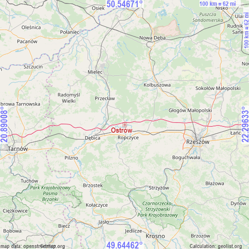
Ostrów GPS coordinates[2]
50° 5' 52.044" North, 21° 35' 35.52" East
| Map corner | latitude | longitude |
|---|---|---|
| Upper-left | 50.54671°, | 20.89008° |
| Center: | 50.09779°, | 21.5932° |
| Lower-right: | 49.64462°, | 22.29633° |
| Map W x H: | 100.3×100.3 km | = 62.3×62.3mi |
| max Lat: | 54.83135° ⇑78.1% North |
| Ostrów: | 50.09779° |
| min Lat: | ⇓21.9% South 49.21328° |
| min Long | Ostrów | max Long |
| 14.20249° | 21.5932° | 24.03723° |
| W 80.2%⇐ | ⇒19.8% E |
Elevation
Elevation of Ostrów is 195 m = 640 ft, and this is 3.6 m = 12 ft above average elevation for this country.
| Max E: |
974 m = 3196 ft | 41.5% |
| Ostrów | 195 m 640 ft | |
| Avg. | 191.4 m = 628 ft | |
Min E: |
-3 m = -10 ft | 58.5% |
See also: Poland elevation on elevation.city.
Geographical zone
Ostrów is located in North temperate zone (between Tropic of Cancer and the Arctic Circle). Distance of this North polar circle is 1830.8 km =1137.6 mi to North.| Distance of | km | miles | from Ostrów |
|---|---|---|---|
| North Pole | 4436.7 | 2756.8 | to North |
| Arctic Circle | 1830.8 | 1137.6 | to North |
| Tropic Cancer | 2964.4 | 1842 | to South |
| Equator | 5570.4 | 3461.3 | to South |


Nearby cities:
15 places around Ostrów: (largest is in red/bold)
• Brzeźnica
8.1 km =5 mi,  272°
272°
• Bystrzyca
16.5 km =10.3 mi,  143°
143°
• Błonie
15 km =9.3 mi,  328°
328°
• Dębica
14 km =8.7 mi,  248°
248°
• Iwierzyce
13.8 km =8.6 mi,  123°
123°
• Krzywa
10.1 km =6.3 mi,  88°
88°
• Niedźwiada
13.1 km =8.1 mi,  202°
202°
• Niwiska
14.4 km =8.9 mi,  10°
10°
• Przecław
13.3 km =8.3 mi,  322°
322°
• Ropczyce
5.2 km =3.2 mi,  167°
167°
• Sędziszów Małopolski
8.2 km =5.1 mi,  111°
111°
• Trześń
15.1 km =9.4 mi,  22°
22°
• Wiśniowa
16 km =9.9 mi,  133°
133°
• Zagórzyce
10.7 km =6.6 mi,  146°
146°
• Żyraków
14.1 km =8.8 mi,  264°
264°
Sources, notices
• [Note1] Compared only with cities in Poland existing in our database
• [Src1] Map data: © OpenStreetMap contributors (CC-BY-SA)
• [Src2] Other city data from geonames.org with taken over terms of usage.
• [Src3] Geographical zone / Annual Mean Temperature by Robert A. Rohde @ Wikipedia
