Cmolas geodata
Cmolas (Subcarpathian) is a seat of a third-order administrative division; located in Poland in Europe/Warsaw (GMT+2) time zone. With population of 4,000 people, there are 814 cities with bigger population in this country. Compared to other cities in Poland, 72.2% of cities are located further ↑North; 81.6% of cities are located further ←West and 64.8% of cities have lower elevation than Cmolas. Note1


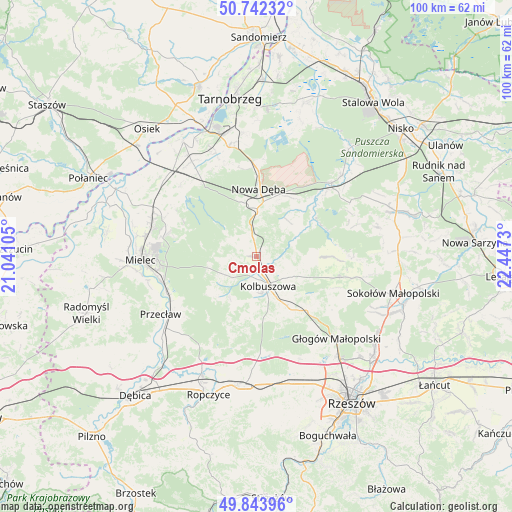
Cmolas GPS coordinates[2]
50° 17' 42.936" North, 21° 44' 39.012" East
| Map corner | latitude | longitude |
|---|---|---|
| Upper-left | 50.74232°, | 21.04105° |
| Center: | 50.29526°, | 21.74417° |
| Lower-right: | 49.84396°, | 22.4473° |
| Map W x H: | 99.9×99.9 km | = 62.1×62.1mi |
| max Lat: | 54.83135° ⇑72.2% North |
| Cmolas: | 50.29526° |
| min Lat: | ⇓27.8% South 49.21328° |
| min Long | Cmolas | max Long |
| 14.20249° | 21.74417° | 24.03723° |
| W 81.6%⇐ | ⇒18.4% E |
Elevation
Elevation of Cmolas is 214 m = 702 ft, and this is 22.6 m = 74 ft above average elevation for this country.
| Max E: |
974 m = 3196 ft | 35.2% |
| Cmolas | 214 m 702 ft | |
| Avg. | 191.4 m = 628 ft | |
Min E: |
-3 m = -10 ft | 64.8% |
See also: Poland elevation on elevation.city.
Geographical zone
Cmolas is located in North temperate zone (between Tropic of Cancer and the Arctic Circle). Distance of this North polar circle is 1808.9 km =1124 mi to North.| Distance of | km | miles | from Cmolas |
|---|---|---|---|
| North Pole | 4414.8 | 2743.2 | to North |
| Arctic Circle | 1808.9 | 1124 | to North |
| Tropic Cancer | 2986.4 | 1855.7 | to South |
| Equator | 5592.3 | 3474.9 | to South |


Nearby cities:
15 places around Cmolas: (largest is in red/bold)
• Bojanów
20.6 km =12.8 mi,  45°
45°
• Błonie
20.6 km =12.8 mi,  243°
243°
• Dzikowiec
7.5 km =4.7 mi,  109°
109°
• Gwoździec
19.7 km =12.2 mi,  62°
62°
• Kolbuszowa
6.1 km =3.8 mi,  158°
158°
• Lipnica
10.2 km =6.3 mi,  93°
93°
• Majdan Królewski
9.4 km =5.8 mi,  0°
0°
• Mechowiec
4.9 km =3 mi,  101°
101°
• Niwiska
11.3 km =7 mi,  225°
225°
• Nowa Dęba
15 km =9.3 mi, 1°
• Ostrowy Baranowskie
7.7 km =4.8 mi,  307°
307°
• Ostrowy Tuszowskie
7 km =4.3 mi,  290°
290°
• Przyłęk
10 km =6.2 mi,  257°
257°
• Raniżów
16.6 km =10.3 mi, 104°
• Trześń
9.4 km =5.8 mi,  212°
212°
Sources, notices
• [Note1] Compared only with cities in Poland existing in our database
• [Src1] Map data: © OpenStreetMap contributors (CC-BY-SA)
• [Src2] Other city data from geonames.org with taken over terms of usage.
• [Src3] Geographical zone / Annual Mean Temperature by Robert A. Rohde @ Wikipedia
