Błonie geodata
Błonie (Subcarpathian) is a populated place; located in Poland in Europe/Warsaw (GMT+2) time zone. With population of 653 people, there are 3158 cities with bigger population in this country. Compared to other cities in Poland, 74.1% of cities are located further ↑North; 79% of cities are located further ←West and 50.6% of cities have lower elevation than Błonie. Note1


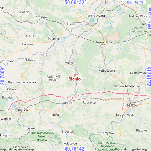
Błonie GPS coordinates[2]
50° 12' 48.564" North, 21° 29' 2.472" East
| Map corner | latitude | longitude |
|---|---|---|
| Upper-left | 50.66132°, | 20.7809° |
| Center: | 50.21349°, | 21.48402° |
| Lower-right: | 49.76142°, | 22.18715° |
| Map W x H: | 100.1×100.1 km | = 62.2×62.2mi |
| max Lat: | 54.83135° ⇑74.1% North |
| Błonie: | 50.21349° |
| min Lat: | ⇓25.9% South 49.21328° |
| min Long | Błonie | max Long |
| 14.20249° | 21.48402° | 24.03723° |
| W 79%⇐ | ⇒21% E |
Elevation
Elevation of Błonie is 173 m = 568 ft, and this is 18.4 m = 60 ft below average elevation for this country.
| Max E: |
974 m = 3196 ft | 49.4% |
| Avg. | 191.4 m = 628 ft | |
| Błonie | 173 m = 568 ft | |
Min E: |
-3 m = -10 ft | 50.6% |
See also: Poland elevation on elevation.city.
Geographical zone
Błonie is located in North temperate zone (between Tropic of Cancer and the Arctic Circle). Distance of this North polar circle is 1818 km =1129.7 mi to North.| Distance of | km | miles | from Błonie |
|---|---|---|---|
| North Pole | 4423.8 | 2748.8 | to North |
| Arctic Circle | 1818 | 1129.7 | to North |
| Tropic Cancer | 2977.3 | 1850 | to South |
| Equator | 5583.2 | 3469.2 | to South |


Nearby cities:
15 places around Błonie: (largest is in red/bold)
• Brzeźnica
12.5 km =7.8 mi,  181°
181°
• Czermin
17.6 km =10.9 mi,  322°
322°
• Mielec
9.2 km =5.7 mi,  332°
332°
• Niwiska
10.5 km =6.5 mi,  83°
83°
• Ostrowy Baranowskie
18.6 km =11.6 mi,  41°
41°
• Ostrowy Tuszowskie
16.6 km =10.3 mi,  45°
45°
• Ostrów
15 km =9.3 mi,  148°
148°
• Przecław
2.3 km =1.4 mi,  187°
187°
• Przyłęk
11.1 km =6.9 mi, 51°
• Radomyśl Wielki
14.9 km =9.3 mi,  262°
262°
• Trzciana
14.8 km =9.2 mi, 315°
• Trześń
13.5 km =8.4 mi,  85°
85°
• Tuszów Narodowy
17.8 km =11.1 mi,  354°
354°
• Wadowice Górne
14.1 km =8.8 mi,  293°
293°
• Żyraków
15.6 km =9.7 mi,  203°
203°
Sources, notices
• [Note1] Compared only with cities in Poland existing in our database
• [Src1] Map data: © OpenStreetMap contributors (CC-BY-SA)
• [Src2] Other city data from geonames.org with taken over terms of usage.
• [Src3] Geographical zone / Annual Mean Temperature by Robert A. Rohde @ Wikipedia
