Swarzów geodata
Swarzów (Lesser Poland) is a populated place; located in Poland in Europe/Warsaw (GMT+2) time zone. With population of 751 people, there are 2951 cities with bigger population in this country. Compared to other cities in Poland, 74.6% of cities are located further ↑North; 71.8% of cities are located further ←West and 53% of cities have lower elevation than Swarzów. Note1


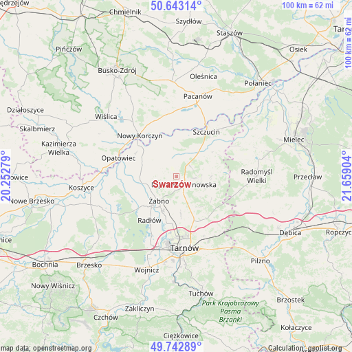
Swarzów GPS coordinates[2]
50° 11' 42.504" North, 20° 57' 21.276" East
| Map corner | latitude | longitude |
|---|---|---|
| Upper-left | 50.64314°, | 20.25279° |
| Center: | 50.19514°, | 20.95591° |
| Lower-right: | 49.74289°, | 21.65904° |
| Map W x H: | 100.1×100.1 km | = 62.2×62.2mi |
| max Lat: | 54.83135° ⇑74.6% North |
| Swarzów: | 50.19514° |
| min Lat: | ⇓25.4% South 49.21328° |
| min Long | Swarzów | max Long |
| 14.20249° | 20.95591° | 24.03723° |
| W 71.8%⇐ | ⇒28.2% E |
Elevation
Elevation of Swarzów is 180 m = 591 ft, and this is 11.4 m = 37 ft below average elevation for this country.
| Max E: |
974 m = 3196 ft | 47% |
| Avg. | 191.4 m = 628 ft | |
| Swarzów | 180 m = 591 ft | |
Min E: |
-3 m = -10 ft | 53% |
See also: Poland elevation on elevation.city.
Geographical zone
Swarzów is located in North temperate zone (between Tropic of Cancer and the Arctic Circle). Distance of this North polar circle is 1820 km =1130.9 mi to North.| Distance of | km | miles | from Swarzów |
|---|---|---|---|
| North Pole | 4425.9 | 2750.1 | to North |
| Arctic Circle | 1820 | 1130.9 | to North |
| Tropic Cancer | 2975.3 | 1848.8 | to South |
| Equator | 5581.2 | 3468 | to South |


Nearby cities:
15 places around Swarzów: (largest is in red/bold)
• Biskupice Radłowskie
10.8 km =6.7 mi,  219°
219°
• Bolesław
9.5 km =5.9 mi,  335°
335°
• Dąbrowa Tarnowska
3.1 km =1.9 mi,  136°
136°
• Gorzyce
6.9 km =4.3 mi,  259°
259°
• Gruszów Wielki
5.4 km =3.4 mi,  94°
94°
• Mędrzechów
9.7 km =6 mi,  356°
356°
• Nieciecza
8.9 km =5.5 mi,  237°
237°
• Niedomice
10.7 km =6.6 mi,  203°
203°
• Odporyszów
5.7 km =3.5 mi,  213°
213°
• Olesno
2.3 km =1.4 mi,  288°
288°
• Radgoszcz
11.3 km =7 mi,  83°
83°
• Sieradza
6.9 km =4.3 mi, 195°
• Smęgorzów
5 km =3.1 mi,  42°
42°
• Łukowa
11.4 km =7.1 mi,  172°
172°
• Żabno
8.5 km =5.3 mi, 215°
Sources, notices
• [Note1] Compared only with cities in Poland existing in our database
• [Src1] Map data: © OpenStreetMap contributors (CC-BY-SA)
• [Src2] Other city data from geonames.org with taken over terms of usage.
• [Src3] Geographical zone / Annual Mean Temperature by Robert A. Rohde @ Wikipedia
