Dębno geodata
Dębno (Lesser Poland) is a populated place; located in Poland in Europe/Warsaw (GMT+2) time zone. With population of 822 people, there are 2815 cities with bigger population in this country. Compared to other cities in Poland, 98.9% of cities are located further ↑North; 61.3% of cities are located further ←West and 98% of cities have lower elevation than Dębno. Note1


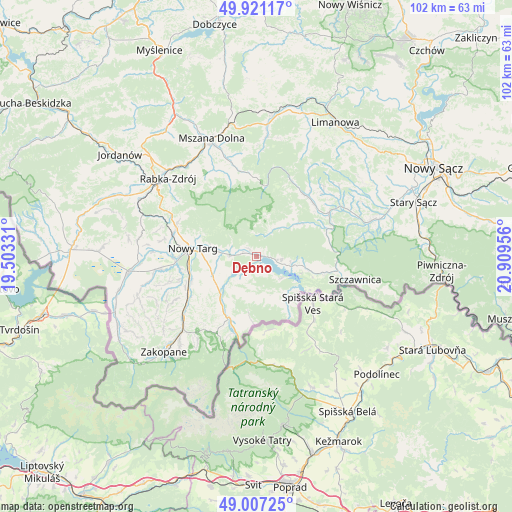
Dębno GPS coordinates[2]
49° 27' 58.824" North, 20° 12' 23.148" East
| Map corner | latitude | longitude |
|---|---|---|
| Upper-left | 49.92117°, | 19.50331° |
| Center: | 49.46634°, | 20.20643° |
| Lower-right: | 49.00725°, | 20.90956° |
| Map W x H: | 101.6×101.6 km | = 63.1×63.1mi |
| max Lat: | 54.83135° ⇑98.9% North |
| Dębno: | 49.46634° |
| min Lat: | ⇓1.1% South 49.21328° |
| min Long | Dębno | max Long |
| 14.20249° | 20.20643° | 24.03723° |
| W 61.3%⇐ | ⇒38.7% E |
Elevation
Elevation of Dębno is 537 m = 1762 ft, and this is 345.6 m = 1134 ft above average elevation for this country.
| Max E: |
974 m = 3196 ft | 2% |
| Dębno | 537 m 1762 ft | |
| Avg. | 191.4 m = 628 ft | |
Min E: |
-3 m = -10 ft | 98% |
See also: Poland elevation on elevation.city.
Geographical zone
Dębno is located in North temperate zone (between Tropic of Cancer and the Arctic Circle). Distance of this North polar circle is 1901 km =1181.2 mi to North.| Distance of | km | miles | from Dębno |
|---|---|---|---|
| North Pole | 4506.9 | 2800.5 | to North |
| Arctic Circle | 1901 | 1181.2 | to North |
| Tropic Cancer | 2894.2 | 1798.4 | to South |
| Equator | 5500.1 | 3417.6 | to South |


Nearby cities:
15 places around Dębno: (largest is in red/bold)
• Białka Tatrzańska
11.2 km =7 mi,  220°
220°
• Czarna Góra
11.4 km =7.1 mi,  208°
208°
• Frydman
2.5 km =1.6 mi,  138°
138°
• Kluszkowce
7.1 km =4.4 mi,  103°
103°
• Krośnica
9.8 km =6.1 mi, 102°
• Leśnica
12.8 km =8 mi,  235°
235°
• Maniowy
4.3 km =2.7 mi, 99°
• Niedzica
9.4 km =5.8 mi,  131°
131°
• Nowy Targ
12.6 km =7.8 mi,  275°
275°
• Ochotnica Dolna
11.9 km =7.4 mi,  55°
55°
• Ostrowsko
7.7 km =4.8 mi, 278°
• Szlembark
1.1 km =0.7 mi,  21°
21°
• Waksmund
9.6 km =6 mi, 280°
• Łapsze Niżne
8 km =5 mi,  160°
160°
• Łopuszna
5.6 km =3.5 mi, 277°
Sources, notices
• [Note1] Compared only with cities in Poland existing in our database
• [Src1] Map data: © OpenStreetMap contributors (CC-BY-SA)
• [Src2] Other city data from geonames.org with taken over terms of usage.
• [Src3] Geographical zone / Annual Mean Temperature by Robert A. Rohde @ Wikipedia
