Korzenna geodata
Korzenna (Lesser Poland) is a populated place; located in Poland in Europe/Warsaw (GMT+2) time zone. With population of 1,700 people, there are 1678 cities with bigger population in this country. Compared to other cities in Poland, 94.9% of cities are located further ↑North; 69.8% of cities are located further ←West and 91.4% of cities have lower elevation than Korzenna. Note1


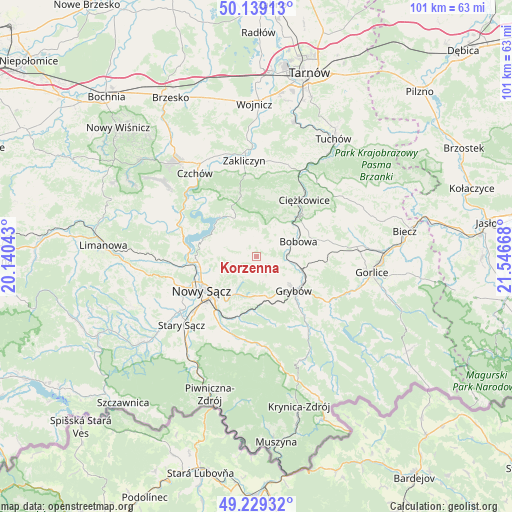
Korzenna GPS coordinates[2]
49° 41' 10.86" North, 20° 50' 36.78" East
| Map corner | latitude | longitude |
|---|---|---|
| Upper-left | 50.13913°, | 20.14043° |
| Center: | 49.68635°, | 20.84355° |
| Lower-right: | 49.22932°, | 21.54668° |
| Map W x H: | 101.2×101.2 km | = 62.9×62.9mi |
| max Lat: | 54.83135° ⇑94.9% North |
| Korzenna: | 49.68635° |
| min Lat: | ⇓5.1% South 49.21328° |
| min Long | Korzenna | max Long |
| 14.20249° | 20.84355° | 24.03723° |
| W 69.8%⇐ | ⇒30.2% E |
Elevation
Elevation of Korzenna is 348 m = 1142 ft, and this is 156.6 m = 514 ft above average elevation for this country.
| Max E: |
974 m = 3196 ft | 8.6% |
| Korzenna | 348 m 1142 ft | |
| Avg. | 191.4 m = 628 ft | |
Min E: |
-3 m = -10 ft | 91.4% |
See also: Poland elevation on elevation.city.
Geographical zone
Korzenna is located in North temperate zone (between Tropic of Cancer and the Arctic Circle). Distance of this North polar circle is 1876.6 km =1166.1 mi to North.| Distance of | km | miles | from Korzenna |
|---|---|---|---|
| North Pole | 4482.5 | 2785.3 | to North |
| Arctic Circle | 1876.6 | 1166.1 | to North |
| Tropic Cancer | 2918.7 | 1813.6 | to South |
| Equator | 5524.6 | 3432.8 | to South |


Nearby cities:
15 places around Korzenna: (largest is in red/bold)
• Bobowa
7.9 km =4.9 mi,  71°
71°
• Bystra
17.7 km =11 mi,  98°
98°
• Chełmiec
14.3 km =8.9 mi,  244°
244°
• Ciężkowice
14.5 km =9 mi,  40°
40°
• Grybów
10.2 km =6.3 mi,  132°
132°
• Gródek Nad Dunajcem
10.4 km =6.5 mi,  309°
309°
• Jastrzębia
12.6 km =7.8 mi,  12°
12°
• Kamionka Wielka
13.2 km =8.2 mi,  186°
186°
• Lipnica Wielka
2.7 km =1.7 mi, 40°
• Nawojowa
15.3 km =9.5 mi,  209°
209°
• Nowy Sącz
12.8 km =8 mi, 235°
• Siedlce
4.9 km =3 mi,  271°
271°
• Łabowa
17.7 km =11 mi,  177°
177°
• Łososina Dolna
16.8 km =10.4 mi,  294°
294°
• Łużna
14.9 km =9.3 mi,  78°
78°
Sources, notices
• [Note1] Compared only with cities in Poland existing in our database
• [Src1] Map data: © OpenStreetMap contributors (CC-BY-SA)
• [Src2] Other city data from geonames.org with taken over terms of usage.
• [Src3] Geographical zone / Annual Mean Temperature by Robert A. Rohde @ Wikipedia
