Łabowa geodata
Łabowa (Lesser Poland) is a populated place; located in Poland in Europe/Warsaw (GMT+2) time zone. With population of 1,100 people, there are 2307 cities with bigger population in this country. Compared to other cities in Poland, 97.8% of cities are located further ↑North; 70.1% of cities are located further ←West and 96.4% of cities have lower elevation than Łabowa. Note1


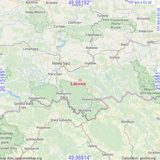
Łabowa GPS coordinates[2]
49° 31' 39.576" North, 20° 51' 17.892" East
| Map corner | latitude | longitude |
|---|---|---|
| Upper-left | 49.98192°, | 20.15185° |
| Center: | 49.52766°, | 20.85497° |
| Lower-right: | 49.06914°, | 21.5581° |
| Map W x H: | 101.5×101.5 km | = 63.1×63.1mi |
| max Lat: | 54.83135° ⇑97.8% North |
| Łabowa: | 49.52766° |
| min Lat: | ⇓2.2% South 49.21328° |
| min Long | Łabowa | max Long |
| 14.20249° | 20.85497° | 24.03723° |
| W 70.1%⇐ | ⇒29.9% E |
Elevation
Elevation of Łabowa is 451 m = 1480 ft, and this is 259.6 m = 852 ft above average elevation for this country.
| Max E: |
974 m = 3196 ft | 3.6% |
| Łabowa | 451 m 1480 ft | |
| Avg. | 191.4 m = 628 ft | |
Min E: |
-3 m = -10 ft | 96.4% |
See also: Poland elevation on elevation.city.
Geographical zone
Łabowa is located in North temperate zone (between Tropic of Cancer and the Arctic Circle). Distance of this North polar circle is 1894.2 km =1177 mi to North.| Distance of | km | miles | from Łabowa |
|---|---|---|---|
| North Pole | 4500.1 | 2796.2 | to North |
| Arctic Circle | 1894.2 | 1177 | to North |
| Tropic Cancer | 2901 | 1802.6 | to South |
| Equator | 5507 | 3421.9 | to South |


Nearby cities:
15 places around Łabowa: (largest is in red/bold)
• Chełmiec
17.9 km =11.1 mi,  309°
309°
• Grybów
12.7 km =7.9 mi,  31°
31°
• Kamionka Wielka
5.1 km =3.2 mi,  333°
333°
• Korzenna
17.7 km =11 mi,  357°
357°
• Krynica-Zdrój
13.9 km =8.6 mi,  147°
147°
• Lipnica Wielka
19.7 km =12.2 mi,  2°
2°
• Muszyna
19.3 km =12 mi,  170°
170°
• Nawojowa
9.4 km =5.8 mi,  297°
297°
• Nowy Sącz
15.5 km =9.6 mi, 312°
• Piwniczna-Zdrój
14 km =8.7 mi,  226°
226°
• Ropa
15.4 km =9.6 mi,  62°
62°
• Rytro
14.3 km =8.9 mi,  252°
252°
• Siedlce
18.7 km =11.6 mi,  342°
342°
• Stary Sącz
16.4 km =10.2 mi,  284°
284°
• Tylicz
19.1 km =11.9 mi,  140°
140°
Sources, notices
• [Note1] Compared only with cities in Poland existing in our database
• [Src1] Map data: © OpenStreetMap contributors (CC-BY-SA)
• [Src2] Other city data from geonames.org with taken over terms of usage.
• [Src3] Geographical zone / Annual Mean Temperature by Robert A. Rohde @ Wikipedia
