Grybów geodata
Grybów (Lesser Poland) is a populated place; located in Poland in Europe/Warsaw (GMT+2) time zone. With population of 5,994 people, there are 606 cities with bigger population in this country. Compared to other cities in Poland, 96.1% of cities are located further ↑North; 71.6% of cities are located further ←West and 90.1% of cities have lower elevation than Grybów. Note1


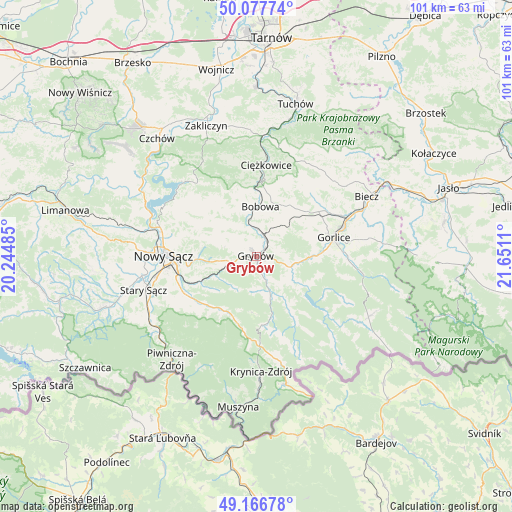
Grybów GPS coordinates[2]
49° 37' 27.804" North, 20° 56' 52.692" East
| Map corner | latitude | longitude |
|---|---|---|
| Upper-left | 50.07774°, | 20.24485° |
| Center: | 49.62439°, | 20.94797° |
| Lower-right: | 49.16678°, | 21.6511° |
| Map W x H: | 101.3×101.3 km | = 62.9×62.9mi |
| max Lat: | 54.83135° ⇑96.1% North |
| Grybów: | 49.62439° |
| min Lat: | ⇓3.9% South 49.21328° |
| min Long | Grybów | max Long |
| 14.20249° | 20.94797° | 24.03723° |
| W 71.6%⇐ | ⇒28.4% E |
Elevation
Elevation of Grybów is 329 m = 1079 ft, and this is 137.6 m = 451 ft above average elevation for this country.
| Max E: |
974 m = 3196 ft | 9.9% |
| Grybów | 329 m 1079 ft | |
| Avg. | 191.4 m = 628 ft | |
Min E: |
-3 m = -10 ft | 90.1% |
See also: Poland elevation on elevation.city.
Geographical zone
Grybów is located in North temperate zone (between Tropic of Cancer and the Arctic Circle). Distance of this North polar circle is 1883.5 km =1170.4 mi to North.| Distance of | km | miles | from Grybów |
|---|---|---|---|
| North Pole | 4489.3 | 2789.5 | to North |
| Arctic Circle | 1883.5 | 1170.4 | to North |
| Tropic Cancer | 2911.8 | 1809.3 | to South |
| Equator | 5517.7 | 3428.5 | to South |


Nearby cities:
15 places around Grybów: (largest is in red/bold)
• Bobowa
9.4 km =5.8 mi,  359°
359°
• Bystra
10.8 km =6.7 mi,  67°
67°
• Ciężkowice
18 km =11.2 mi,  5°
5°
• Gorlice
15.7 km =9.8 mi,  77°
77°
• Kamionka Wielka
10.9 km =6.8 mi,  235°
235°
• Korzenna
10.2 km =6.3 mi,  312°
312°
• Lipnica Wielka
10.6 km =6.6 mi,  327°
327°
• Moszczenica
16.2 km =10.1 mi,  39°
39°
• Nawojowa
16.3 km =10.1 mi,  246°
246°
• Ropa
7.8 km =4.8 mi,  117°
117°
• Siedlce
14.2 km =8.8 mi,  299°
299°
• Sękowa
18 km =11.2 mi,  90°
90°
• Uście Gorlickie
17.8 km =11.1 mi,  129°
129°
• Łabowa
12.7 km =7.9 mi,  211°
211°
• Łużna
12.1 km =7.5 mi, 35°
Sources, notices
• [Note1] Compared only with cities in Poland existing in our database
• [Src1] Map data: © OpenStreetMap contributors (CC-BY-SA)
• [Src2] Other city data from geonames.org with taken over terms of usage.
• [Src3] Geographical zone / Annual Mean Temperature by Robert A. Rohde @ Wikipedia
