Kamionka Wielka geodata
Kamionka Wielka (Lesser Poland) is a populated place; located in Poland in Europe/Warsaw (GMT+2) time zone. With population of 2,925 people, there are 1081 cities with bigger population in this country. Compared to other cities in Poland, 97.1% of cities are located further ↑North; 69.6% of cities are located further ←West and 96.1% of cities have lower elevation than Kamionka Wielka. Note1
Administrative division(s):
- Level 1: Lesser Poland
- Level 2: Powiat nowosądecki
- Level 3: Kamionka Wielka


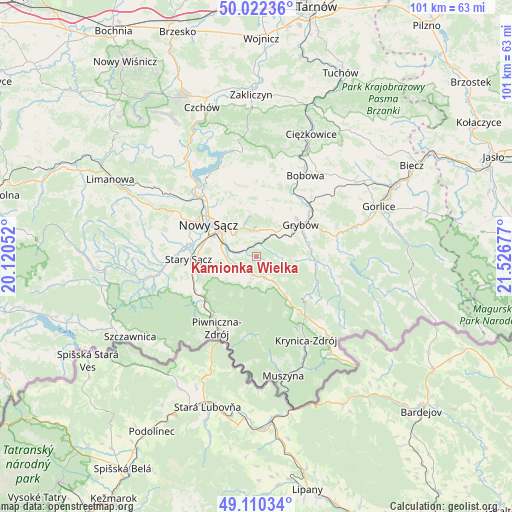
Kamionka Wielka GPS coordinates[2]
49° 34' 6.528" North, 20° 49' 25.104" East
| Map corner | latitude | longitude |
|---|---|---|
| Upper-left | 50.02236°, | 20.12052° |
| Center: | 49.56848°, | 20.82364° |
| Lower-right: | 49.11034°, | 21.52677° |
| Map W x H: | 101.4×101.4 km | = 63×63mi |
| max Lat: | 54.83135° ⇑97.1% North |
| Kamionka Wielka: | 49.56848° |
| min Lat: | ⇓2.9% South 49.21328° |
| min Long | Kamionka Wielka | max Long |
| 14.20249° | 20.82364° | 24.03723° |
| W 69.6%⇐ | ⇒30.4% E |
Elevation
Elevation of Kamionka Wielka is 447 m = 1467 ft, and this is 255.6 m = 839 ft above average elevation for this country.
| Max E: |
974 m = 3196 ft | 3.9% |
| Kamionka Wielka | 447 m 1467 ft | |
| Avg. | 191.4 m = 628 ft | |
Min E: |
-3 m = -10 ft | 96.1% |
See also: Poland elevation on elevation.city.
Geographical zone
Kamionka Wielka is located in North temperate zone (between Tropic of Cancer and the Arctic Circle). Distance of this North polar circle is 1889.7 km =1174.2 mi to North.| Distance of | km | miles | from Kamionka Wielka |
|---|---|---|---|
| North Pole | 4495.6 | 2793.4 | to North |
| Arctic Circle | 1889.7 | 1174.2 | to North |
| Tropic Cancer | 2905.6 | 1805.5 | to South |
| Equator | 5511.5 | 3424.7 | to South |


Nearby cities:
15 places around Kamionka Wielka: (largest is in red/bold)
• Bobowa
18 km =11.2 mi,  29°
29°
• Chełmiec
13.4 km =8.3 mi,  300°
300°
• Grybów
10.9 km =6.8 mi,  55°
55°
• Korzenna
13.2 km =8.2 mi,  6°
6°
• Krynica-Zdrój
19 km =11.8 mi,  148°
148°
• Lipnica Wielka
15.5 km =9.6 mi, 12°
• Nawojowa
6.1 km =3.8 mi,  268°
268°
• Nowy Sącz
10.9 km =6.8 mi, 303°
• Piwniczna-Zdrój
16.3 km =10.1 mi,  209°
209°
• Podegrodzie
17 km =10.6 mi, 273°
• Ropa
16.1 km =10 mi,  80°
80°
• Rytro
14.4 km =8.9 mi,  232°
232°
• Siedlce
13.7 km =8.5 mi,  345°
345°
• Stary Sącz
13.6 km =8.5 mi, 267°
• Łabowa
5.1 km =3.2 mi, 153°
Sources, notices
• [Note1] Compared only with cities in Poland existing in our database
• [Src1] Map data: © OpenStreetMap contributors (CC-BY-SA)
• [Src2] Other city data from geonames.org with taken over terms of usage.
• [Src3] Geographical zone / Annual Mean Temperature by Robert A. Rohde @ Wikipedia
