Chełmiec geodata
Chełmiec (Lesser Poland) is a populated place; located in Poland in Europe/Warsaw (GMT+2) time zone. With population of 2,657 people, there are 1184 cities with bigger population in this country. Compared to other cities in Poland, 96% of cities are located further ↑North; 67% of cities are located further ←West and 83.2% of cities have lower elevation than Chełmiec. Note1


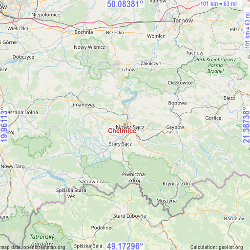
Chełmiec GPS coordinates[2]
49° 37' 49.836" North, 20° 39' 51.3" East
| Map corner | latitude | longitude |
|---|---|---|
| Upper-left | 50.08381°, | 19.96113° |
| Center: | 49.63051°, | 20.66425° |
| Lower-right: | 49.17296°, | 21.36738° |
| Map W x H: | 101.3×101.3 km | = 62.9×62.9mi |
| max Lat: | 54.83135° ⇑96% North |
| Chełmiec: | 49.63051° |
| min Lat: | ⇓4% South 49.21328° |
| min Long | Chełmiec | max Long |
| 14.20249° | 20.66425° | 24.03723° |
| W 67%⇐ | ⇒33% E |
Elevation
Elevation of Chełmiec is 281 m = 922 ft, and this is 89.6 m = 294 ft above average elevation for this country.
| Max E: |
974 m = 3196 ft | 16.8% |
| Chełmiec | 281 m 922 ft | |
| Avg. | 191.4 m = 628 ft | |
Min E: |
-3 m = -10 ft | 83.2% |
See also: Poland elevation on elevation.city.
Geographical zone
Chełmiec is located in North temperate zone (between Tropic of Cancer and the Arctic Circle). Distance of this North polar circle is 1882.8 km =1169.9 mi to North.| Distance of | km | miles | from Chełmiec |
|---|---|---|---|
| North Pole | 4488.7 | 2789.1 | to North |
| Arctic Circle | 1882.8 | 1169.9 | to North |
| Tropic Cancer | 2912.5 | 1809.7 | to South |
| Equator | 5518.4 | 3429 | to South |


Nearby cities:
15 places around Chełmiec: (largest is in red/bold)
• Gródek Nad Dunajcem
13.8 km =8.6 mi,  20°
20°
• Jastrzębie
14.1 km =8.8 mi,  252°
252°
• Kamionka Wielka
13.4 km =8.3 mi,  120°
120°
• Korzenna
14.3 km =8.9 mi,  64°
64°
• Naszacowice
10.8 km =6.7 mi,  226°
226°
• Nawojowa
8.9 km =5.5 mi,  142°
142°
• Nowy Sącz
2.6 km =1.6 mi,  112°
112°
• Olszana
12.5 km =7.8 mi,  235°
235°
• Olszanka
12.1 km =7.5 mi, 226°
• Podegrodzie
8.1 km =5 mi,  222°
222°
• Siedlce
10.3 km =6.4 mi,  51°
51°
• Stary Sącz
7.7 km =4.8 mi,  195°
195°
• Wysokie
9.1 km =5.7 mi,  286°
286°
• Łososina Dolna
13.5 km =8.4 mi,  349°
349°
• Łukowica
13.2 km =8.2 mi,  260°
260°
Sources, notices
• [Note1] Compared only with cities in Poland existing in our database
• [Src1] Map data: © OpenStreetMap contributors (CC-BY-SA)
• [Src2] Other city data from geonames.org with taken over terms of usage.
• [Src3] Geographical zone / Annual Mean Temperature by Robert A. Rohde @ Wikipedia
