Karczew geodata
Karczew (Mazovia) is a seat of a third-order administrative division; located in Poland in Europe/Warsaw (GMT+2) time zone. With population of 10,319 people, there are 436 cities with bigger population in this country. Compared to other cities in Poland, 67.1% of cities are located further ↓South; 76.4% of cities are located further ←West and 84.6% of cities have higher elevation than Karczew. Note1


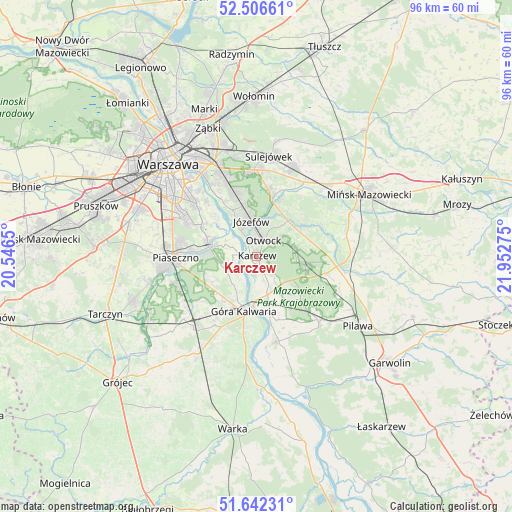
Karczew GPS coordinates[2]
52° 4' 35.58" North, 21° 14' 58.632" East
| Map corner | latitude | longitude |
|---|---|---|
| Upper-left | 52.50661°, | 20.5465° |
| Center: | 52.07655°, | 21.24962° |
| Lower-right: | 51.64231°, | 21.95275° |
| Map W x H: | 96.1×96.1 km | = 59.7×59.7mi |
| max Lat: | 54.83135° ⇑32.9% North |
| Karczew: | 52.07655° |
| min Lat: | ⇓67.1% South 49.21328° |
| min Long | Karczew | max Long |
| 14.20249° | 21.24962° | 24.03723° |
| W 76.4%⇐ | ⇒23.6% E |
Elevation
Elevation of Karczew is 90 m = 295 ft, and this is 101.4 m = 333 ft below average elevation for this country.
| Max E: |
974 m = 3196 ft | 84.6% |
| Avg. | 191.4 m = 628 ft | |
| Karczew | 90 m = 295 ft | |
Min E: |
-3 m = -10 ft | 15.4% |
See also: Poland elevation on elevation.city.
Geographical zone
Karczew is located in North temperate zone (between Tropic of Cancer and the Arctic Circle). Distance of this North polar circle is 1610.8 km =1000.9 mi to North.| Distance of | km | miles | from Karczew |
|---|---|---|---|
| North Pole | 4216.7 | 2620.1 | to North |
| Arctic Circle | 1610.8 | 1000.9 | to North |
| Tropic Cancer | 3184.5 | 1978.8 | to South |
| Equator | 5790.4 | 3598 | to South |


Nearby cities:
15 places around Karczew: (largest is in red/bold)
• Baniocha
10 km =6.2 mi,  228°
228°
• Bielawa
8.8 km =5.5 mi,  294°
294°
• Celestynów
9.8 km =6.1 mi,  100°
100°
• Chylice
12.8 km =8 mi,  270°
270°
• Chyliczki
12.3 km =7.6 mi, 274°
• Czarnów
10.6 km =6.6 mi,  257°
257°
• Czersk
13.2 km =8.2 mi,  185°
185°
• Góra Kalwaria
11.4 km =7.1 mi, 191°
• Józefosław
14.1 km =8.8 mi,  280°
280°
• Józefów
6.8 km =4.2 mi,  352°
352°
• Kabaty
12.9 km =8 mi,  297°
297°
• Konstancin-Jeziorna
9.2 km =5.7 mi, 282°
• Otwock
3.3 km =2.1 mi,  13°
13°
• Wiązowna
10.8 km =6.7 mi,  15°
15°
• Żabieniec
13.9 km =8.6 mi, 261°
Sources, notices
• [Note1] Compared only with cities in Poland existing in our database
• [Src1] Map data: © OpenStreetMap contributors (CC-BY-SA)
• [Src2] Other city data from geonames.org with taken over terms of usage.
• [Src3] Geographical zone / Annual Mean Temperature by Robert A. Rohde @ Wikipedia
