Tarczyn geodata
Tarczyn (Mazovia) is a seat of a third-order administrative division; located in Poland in Europe/Warsaw (GMT+2) time zone. With population of 3,904 people, there are 833 cities with bigger population in this country. Compared to other cities in Poland, 65.5% of cities are located further ↓South; 69.7% of cities are located further ←West and 60.6% of cities have higher elevation than Tarczyn. Note1


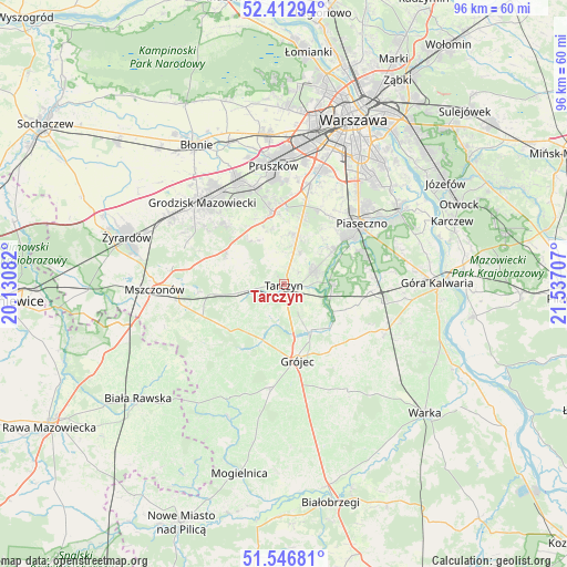
Tarczyn GPS coordinates[2]
51° 58' 55.092" North, 20° 50' 2.184" East
| Map corner | latitude | longitude |
|---|---|---|
| Upper-left | 52.41294°, | 20.13082° |
| Center: | 51.98197°, | 20.83394° |
| Lower-right: | 51.54681°, | 21.53707° |
| Map W x H: | 96.3×96.3 km | = 59.8×59.8mi |
| max Lat: | 54.83135° ⇑34.5% North |
| Tarczyn: | 51.98197° |
| min Lat: | ⇓65.5% South 49.21328° |
| min Long | Tarczyn | max Long |
| 14.20249° | 20.83394° | 24.03723° |
| W 69.7%⇐ | ⇒30.3% E |
Elevation
Elevation of Tarczyn is 145 m = 476 ft, and this is 46.4 m = 152 ft below average elevation for this country.
| Max E: |
974 m = 3196 ft | 60.6% |
| Avg. | 191.4 m = 628 ft | |
| Tarczyn | 145 m = 476 ft | |
Min E: |
-3 m = -10 ft | 39.4% |
See also: Poland elevation on elevation.city.
Geographical zone
Tarczyn is located in North temperate zone (between Tropic of Cancer and the Arctic Circle). Distance of this North polar circle is 1621.3 km =1007.4 mi to North.| Distance of | km | miles | from Tarczyn |
|---|---|---|---|
| North Pole | 4227.2 | 2626.7 | to North |
| Arctic Circle | 1621.3 | 1007.4 | to North |
| Tropic Cancer | 3173.9 | 1972.2 | to South |
| Equator | 5779.9 | 3591.5 | to South |


Nearby cities:
15 places around Tarczyn: (largest is in red/bold)
• Gołków
11.5 km =7.1 mi,  54°
54°
• Grójec
13.5 km =8.4 mi,  170°
170°
• Jazgarzew
12.8 km =8 mi,  60°
60°
• Kamionka
13.2 km =8.2 mi, 50°
• Książenice
14.2 km =8.8 mi,  318°
318°
• Lesznowola
13.9 km =8.6 mi,  29°
29°
• Nadarzyn
12.6 km =7.8 mi,  351°
351°
• Nowa Iwiczna
16.9 km =10.5 mi,  43°
43°
• Otrębusy
17 km =10.6 mi,  342°
342°
• Owczarnia
16.9 km =10.5 mi,  328°
328°
• Pniewy
9.6 km =6 mi,  218°
218°
• Prażmów
9.5 km =5.9 mi,  119°
119°
• Zalesie Górne
14.8 km =9.2 mi,  69°
69°
• Żabia Wola
11.2 km =7 mi,  299°
299°
• Żabieniec
17 km =10.6 mi, 59°
Sources, notices
• [Note1] Compared only with cities in Poland existing in our database
• [Src1] Map data: © OpenStreetMap contributors (CC-BY-SA)
• [Src2] Other city data from geonames.org with taken over terms of usage.
• [Src3] Geographical zone / Annual Mean Temperature by Robert A. Rohde @ Wikipedia
