Golcowa geodata
Golcowa (Subcarpathian) is a populated place; located in Poland in Europe/Warsaw (GMT+2) time zone. With population of 2,200 people, there are 1362 cities with bigger population in this country. Compared to other cities in Poland, 92.7% of cities are located further ↑North; 85.1% of cities are located further ←West and 83.6% of cities have lower elevation than Golcowa. Note1


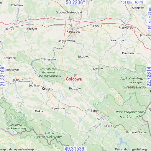
Golcowa GPS coordinates[2]
49° 46' 17.832" North, 22° 1' 30.036" East
| Map corner | latitude | longitude |
|---|---|---|
| Upper-left | 50.2236°, | 21.32189° |
| Center: | 49.77162°, | 22.02501° |
| Lower-right: | 49.31539°, | 22.72814° |
| Map W x H: | 101×101 km | = 62.8×62.8mi |
| max Lat: | 54.83135° ⇑92.7% North |
| Golcowa: | 49.77162° |
| min Lat: | ⇓7.3% South 49.21328° |
| min Long | Golcowa | max Long |
| 14.20249° | 22.02501° | 24.03723° |
| W 85.1%⇐ | ⇒14.9% E |
Elevation
Elevation of Golcowa is 283 m = 928 ft, and this is 91.6 m = 301 ft above average elevation for this country.
| Max E: |
974 m = 3196 ft | 16.4% |
| Golcowa | 283 m 928 ft | |
| Avg. | 191.4 m = 628 ft | |
Min E: |
-3 m = -10 ft | 83.6% |
See also: Poland elevation on elevation.city.
Geographical zone
Golcowa is located in North temperate zone (between Tropic of Cancer and the Arctic Circle). Distance of this North polar circle is 1867.1 km =1160.2 mi to North.| Distance of | km | miles | from Golcowa |
|---|---|---|---|
| North Pole | 4473 | 2779.4 | to North |
| Arctic Circle | 1867.1 | 1160.2 | to North |
| Tropic Cancer | 2928.2 | 1819.5 | to South |
| Equator | 5534.1 | 3438.7 | to South |


Nearby cities:
15 places around Golcowa: (largest is in red/bold)
• Białka
11.1 km =6.9 mi,  3°
3°
• Blizne
4.2 km =2.6 mi,  241°
241°
• Brzozów
8.5 km =5.3 mi,  182°
182°
• Domaradz
5.9 km =3.7 mi,  286°
286°
• Gwoźnica Górna
6.6 km =4.1 mi,  342°
342°
• Humniska
10.9 km =6.8 mi,  169°
169°
• Jabłonka
10.8 km =6.7 mi,  142°
142°
• Jasienica Rosielna
6.4 km =4 mi,  249°
249°
• Konieczkowa
10.5 km =6.5 mi,  318°
318°
• Malinówka
10.9 km =6.8 mi,  219°
219°
• Niebocko
11.9 km =7.4 mi,  151°
151°
• Orzechówka
7.3 km =4.5 mi,  231°
231°
• Stara Wieś
6.5 km =4 mi,  193°
193°
• Wesoła
6.2 km =3.9 mi,  59°
59°
• Zmiennica
11.4 km =7.1 mi,  201°
201°
Sources, notices
• [Note1] Compared only with cities in Poland existing in our database
• [Src1] Map data: © OpenStreetMap contributors (CC-BY-SA)
• [Src2] Other city data from geonames.org with taken over terms of usage.
• [Src3] Geographical zone / Annual Mean Temperature by Robert A. Rohde @ Wikipedia
