Krzczonów geodata
Krzczonów (Lublin) is a seat of a third-order administrative division; located in Poland in Europe/Warsaw (GMT+2) time zone. With population of 1,462 people, there are 1905 cities with bigger population in this country. Compared to other cities in Poland, 55.3% of cities are located further ↑North; 93.9% of cities are located further ←West and 73.8% of cities have lower elevation than Krzczonów. Note1


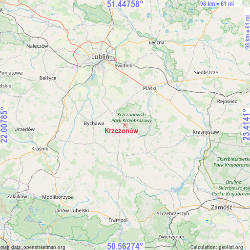
Krzczonów GPS coordinates[2]
51° 0' 26.172" North, 22° 42' 39.492" East
| Map corner | latitude | longitude |
|---|---|---|
| Upper-left | 51.44758°, | 22.00785° |
| Center: | 51.00727°, | 22.71097° |
| Lower-right: | 50.56274°, | 23.4141° |
| Map W x H: | 98.4×98.4 km | = 61.1×61.1mi |
| max Lat: | 54.83135° ⇑55.3% North |
| Krzczonów: | 51.00727° |
| min Lat: | ⇓44.7% South 49.21328° |
| min Long | Krzczonów | max Long |
| 14.20249° | 22.71097° | 24.03723° |
| W 93.9%⇐ | ⇒6.1% E |
Elevation
Elevation of Krzczonów is 242 m = 794 ft, and this is 50.6 m = 166 ft above average elevation for this country.
| Max E: |
974 m = 3196 ft | 26.2% |
| Krzczonów | 242 m 794 ft | |
| Avg. | 191.4 m = 628 ft | |
Min E: |
-3 m = -10 ft | 73.8% |
See also: Poland elevation on elevation.city.
Geographical zone
Krzczonów is located in North temperate zone (between Tropic of Cancer and the Arctic Circle). Distance of this North polar circle is 1729.7 km =1074.8 mi to North.| Distance of | km | miles | from Krzczonów |
|---|---|---|---|
| North Pole | 4335.6 | 2694 | to North |
| Arctic Circle | 1729.7 | 1074.8 | to North |
| Tropic Cancer | 3065.6 | 1904.9 | to South |
| Equator | 5671.5 | 3524.1 | to South |


Nearby cities:
15 places around Krzczonów: (largest is in red/bold)
• Bychawa
12.5 km =7.8 mi,  274°
274°
• Bystrzyca
21.3 km =13.2 mi,  264°
264°
• Fajsławice
20.2 km =12.6 mi,  60°
60°
• Jabłonna
12.2 km =7.6 mi,  317°
317°
• Piaski
17.5 km =10.9 mi,  33°
33°
• Rudnik Pierwszy
19.7 km =12.2 mi, 255°
• Rybczewice
10 km =6.2 mi,  76°
76°
• Strzyżowice
19.5 km =12.1 mi,  283°
283°
• Turobin
20.5 km =12.7 mi,  173°
173°
• Wola Idzikowska
21.5 km =13.4 mi, 62°
• Wysokie
11.2 km =7 mi,  196°
196°
• Zakrzew
15.5 km =9.6 mi,  212°
212°
• Żabia Wola
18.6 km =11.6 mi,  312°
312°
• Żabno
17.7 km =11 mi, 165°
• Żółkiewka
13.9 km =8.6 mi,  141°
141°
Sources, notices
• [Note1] Compared only with cities in Poland existing in our database
• [Src1] Map data: © OpenStreetMap contributors (CC-BY-SA)
• [Src2] Other city data from geonames.org with taken over terms of usage.
• [Src3] Geographical zone / Annual Mean Temperature by Robert A. Rohde @ Wikipedia
