Sawin geodata
Sawin (Lublin) is a populated place; located in Poland in Europe/Warsaw (GMT+2) time zone. With population of 2,181 people, there are 1380 cities with bigger population in this country. Compared to other cities in Poland, 52.6% of cities are located further ↓South; 98.6% of cities are located further ←West and 52.6% of cities have lower elevation than Sawin. Note1


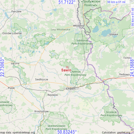
Sawin GPS coordinates[2]
51° 16' 27.948" North, 23° 26' 1.5" East
| Map corner | latitude | longitude |
|---|---|---|
| Upper-left | 51.7122°, | 22.73063° |
| Center: | 51.27443°, | 23.43375° |
| Lower-right: | 50.83245°, | 24.13688° |
| Map W x H: | 97.8×97.8 km | = 60.8×60.8mi |
| max Lat: | 54.83135° ⇑47.4% North |
| Sawin: | 51.27443° |
| min Lat: | ⇓52.6% South 49.21328° |
| min Long | Sawin | max Long |
| 14.20249° | 23.43375° | 24.03723° |
| W 98.6%⇐ | ⇒1.4% E |
Elevation
Elevation of Sawin is 179 m = 587 ft, and this is 12.4 m = 41 ft below average elevation for this country.
| Max E: |
974 m = 3196 ft | 47.4% |
| Avg. | 191.4 m = 628 ft | |
| Sawin | 179 m = 587 ft | |
Min E: |
-3 m = -10 ft | 52.6% |
See also: Poland elevation on elevation.city.
Geographical zone
Sawin is located in North temperate zone (between Tropic of Cancer and the Arctic Circle). Distance of this North polar circle is 1700 km =1056.3 mi to North.| Distance of | km | miles | from Sawin |
|---|---|---|---|
| North Pole | 4305.9 | 2675.6 | to North |
| Arctic Circle | 1700 | 1056.3 | to North |
| Tropic Cancer | 3095.3 | 1923.3 | to South |
| Equator | 5701.2 | 3542.6 | to South |


Nearby cities:
15 places around Sawin: (largest is in red/bold)
• Chełm
14.8 km =9.2 mi,  169°
169°
• Cyców
20.5 km =12.7 mi,  277°
277°
• Hańsk
15.6 km =9.7 mi,  351°
351°
• Kamień
22.4 km =13.9 mi,  151°
151°
• Krasne
23.1 km =14.4 mi,  227°
227°
• Pawłów
21 km =13 mi, 227°
• Pokrówka
20.1 km =12.5 mi, 174°
• Rejowiec
22.9 km =14.2 mi,  207°
207°
• Rejowiec Fabryczny
22.1 km =13.7 mi,  216°
216°
• Ruda-Huta
12 km =7.5 mi,  110°
110°
• Siedliszcze
14.1 km =8.8 mi,  86°
86°
• Siedliszcze
20.8 km =12.9 mi,  244°
244°
• Urszulin
21.3 km =13.2 mi,  308°
308°
• Wola Uhruska
14.4 km =8.9 mi,  68°
68°
• Świerże
21.9 km =13.6 mi, 106°
Sources, notices
• [Note1] Compared only with cities in Poland existing in our database
• [Src1] Map data: © OpenStreetMap contributors (CC-BY-SA)
• [Src2] Other city data from geonames.org with taken over terms of usage.
• [Src3] Geographical zone / Annual Mean Temperature by Robert A. Rohde @ Wikipedia
