Bochnia geodata
Bochnia (Lesser Poland) is a seat of a second-order administrative division; located in Poland in Europe/Warsaw (GMT+2) time zone. With population of 29,184 people, there are 169 cities with bigger population in this country. Compared to other cities in Poland, 84.4% of cities are located further ↑North; 64.1% of cities are located further ←West and 66.4% of cities have lower elevation than Bochnia. Note1


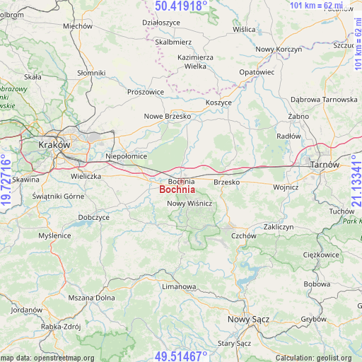
Bochnia GPS coordinates[2]
49° 58' 8.58" North, 20° 25' 49.008" East
| Map corner | latitude | longitude |
|---|---|---|
| Upper-left | 50.41918°, | 19.72716° |
| Center: | 49.96905°, | 20.43028° |
| Lower-right: | 49.51467°, | 21.13341° |
| Map W x H: | 100.6×100.6 km | = 62.5×62.5mi |
| max Lat: | 54.83135° ⇑84.4% North |
| Bochnia: | 49.96905° |
| min Lat: | ⇓15.6% South 49.21328° |
| min Long | Bochnia | max Long |
| 14.20249° | 20.43028° | 24.03723° |
| W 64.1%⇐ | ⇒35.9% E |
Elevation
Elevation of Bochnia is 218 m = 715 ft, and this is 26.6 m = 87 ft above average elevation for this country.
| Max E: |
974 m = 3196 ft | 33.6% |
| Bochnia | 218 m 715 ft | |
| Avg. | 191.4 m = 628 ft | |
Min E: |
-3 m = -10 ft | 66.4% |
See also: Poland elevation on elevation.city.
Geographical zone
Bochnia is located in North temperate zone (between Tropic of Cancer and the Arctic Circle). Distance of this North polar circle is 1845.1 km =1146.5 mi to North.| Distance of | km | miles | from Bochnia |
|---|---|---|---|
| North Pole | 4451 | 2765.7 | to North |
| Arctic Circle | 1845.1 | 1146.5 | to North |
| Tropic Cancer | 2950.1 | 1833.1 | to South |
| Equator | 5556 | 3452.3 | to South |


Nearby cities:
15 places around Bochnia: (largest is in red/bold)
• Baczków
7.2 km =4.5 mi,  6°
6°
• Borek
9 km =5.6 mi,  52°
52°
• Brzeźnica
4.6 km =2.9 mi,  106°
106°
• Damienice
3.5 km =2.2 mi,  317°
317°
• Gierczyce
6.6 km =4.1 mi,  250°
250°
• Jodłówka
8.8 km =5.5 mi,  72°
72°
• Krzeczów
4.7 km =2.9 mi,  61°
61°
• Kłaj
9.7 km =6 mi,  285°
285°
• Nowy Wiśnicz
6.4 km =4 mi,  159°
159°
• Poręba Spytkowska
9.4 km =5.8 mi, 110°
• Rzezawa
6.5 km =4 mi, 69°
• Siedlec
8.1 km =5 mi,  258°
258°
• Stanisławice
5.9 km =3.7 mi, 287°
• Stary Wiśnicz
6.3 km =3.9 mi,  140°
140°
• Łapczyca
3.4 km =2.1 mi, 252°
Sources, notices
• [Note1] Compared only with cities in Poland existing in our database
• [Src1] Map data: © OpenStreetMap contributors (CC-BY-SA)
• [Src2] Other city data from geonames.org with taken over terms of usage.
• [Src3] Geographical zone / Annual Mean Temperature by Robert A. Rohde @ Wikipedia
