Baczków geodata
Baczków (Lesser Poland) is a populated place; located in Poland in Europe/Warsaw (GMT+2) time zone. With population of 753 people, there are 2946 cities with bigger population in this country. Compared to other cities in Poland, 80.7% of cities are located further ↑North; 64.3% of cities are located further ←West and 57.7% of cities have lower elevation than Baczków. Note1


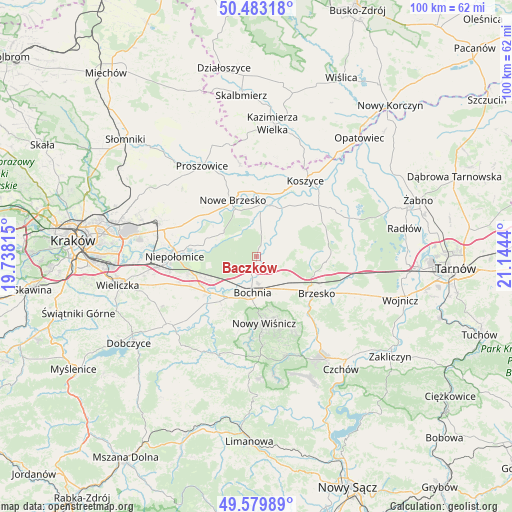
Baczków GPS coordinates[2]
50° 2' 1.176" North, 20° 26' 28.572" East
| Map corner | latitude | longitude |
|---|---|---|
| Upper-left | 50.48318°, | 19.73815° |
| Center: | 50.03366°, | 20.44127° |
| Lower-right: | 49.57989°, | 21.1444° |
| Map W x H: | 100.4×100.4 km | = 62.4×62.4mi |
| max Lat: | 54.83135° ⇑80.7% North |
| Baczków: | 50.03366° |
| min Lat: | ⇓19.3% South 49.21328° |
| min Long | Baczków | max Long |
| 14.20249° | 20.44127° | 24.03723° |
| W 64.3%⇐ | ⇒35.7% E |
Elevation
Elevation of Baczków is 193 m = 633 ft, and this is 1.6 m = 5 ft above average elevation for this country.
| Max E: |
974 m = 3196 ft | 42.3% |
| Baczków | 193 m 633 ft | |
| Avg. | 191.4 m = 628 ft | |
Min E: |
-3 m = -10 ft | 57.7% |
See also: Poland elevation on elevation.city.
Geographical zone
Baczków is located in North temperate zone (between Tropic of Cancer and the Arctic Circle). Distance of this North polar circle is 1838 km =1142.1 mi to North.| Distance of | km | miles | from Baczków |
|---|---|---|---|
| North Pole | 4443.8 | 2761.2 | to North |
| Arctic Circle | 1838 | 1142.1 | to North |
| Tropic Cancer | 2957.3 | 1837.6 | to South |
| Equator | 5563.2 | 3456.8 | to South |


Nearby cities:
15 places around Baczków: (largest is in red/bold)
• Bochnia
7.2 km =4.5 mi,  186°
186°
• Borek
6.6 km =4.1 mi,  105°
105°
• Brzeźnica
9.2 km =5.7 mi,  157°
157°
• Damienice
5.6 km =3.5 mi,  214°
214°
• Drwinia
7.1 km =4.4 mi,  0°
0°
• Dziewin
4.8 km =3 mi,  11°
11°
• Grobla
10.3 km =6.4 mi,  353°
353°
• Jodłówka
8.9 km =5.5 mi,  120°
120°
• Krzeczów
6 km =3.7 mi,  146°
146°
• Rzezawa
7.2 km =4.5 mi,  132°
132°
• Stanisławice
8.4 km =5.2 mi,  230°
230°
• Uście Solne
10.8 km =6.7 mi,  28°
28°
• Wola Zabierzowska
8.9 km =5.5 mi,  299°
299°
• Zabierzów Bocheński
9.5 km =5.9 mi,  293°
293°
• Łapczyca
9.1 km =5.7 mi, 206°
Sources, notices
• [Note1] Compared only with cities in Poland existing in our database
• [Src1] Map data: © OpenStreetMap contributors (CC-BY-SA)
• [Src2] Other city data from geonames.org with taken over terms of usage.
• [Src3] Geographical zone / Annual Mean Temperature by Robert A. Rohde @ Wikipedia
