Rzezawa geodata
Rzezawa (Lesser Poland) is a seat of a third-order administrative division; located in Poland in Europe/Warsaw (GMT+2) time zone. With population of 2,500 people, there are 1240 cities with bigger population in this country. Compared to other cities in Poland, 83% of cities are located further ↑North; 65.2% of cities are located further ←West and 62.2% of cities have lower elevation than Rzezawa. Note1


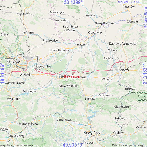
Rzezawa GPS coordinates[2]
49° 59' 23.892" North, 20° 30' 54.288" East
| Map corner | latitude | longitude |
|---|---|---|
| Upper-left | 50.4399°, | 19.81196° |
| Center: | 49.98997°, | 20.51508° |
| Lower-right: | 49.53579°, | 21.21821° |
| Map W x H: | 100.5×100.5 km | = 62.4×62.4mi |
| max Lat: | 54.83135° ⇑83% North |
| Rzezawa: | 49.98997° |
| min Lat: | ⇓17% South 49.21328° |
| min Long | Rzezawa | max Long |
| 14.20249° | 20.51508° | 24.03723° |
| W 65.2%⇐ | ⇒34.8% E |
Elevation
Elevation of Rzezawa is 206 m = 676 ft, and this is 14.6 m = 48 ft above average elevation for this country.
| Max E: |
974 m = 3196 ft | 37.8% |
| Rzezawa | 206 m 676 ft | |
| Avg. | 191.4 m = 628 ft | |
Min E: |
-3 m = -10 ft | 62.2% |
See also: Poland elevation on elevation.city.
Geographical zone
Rzezawa is located in North temperate zone (between Tropic of Cancer and the Arctic Circle). Distance of this North polar circle is 1842.8 km =1145.1 mi to North.| Distance of | km | miles | from Rzezawa |
|---|---|---|---|
| North Pole | 4448.7 | 2764.3 | to North |
| Arctic Circle | 1842.8 | 1145.1 | to North |
| Tropic Cancer | 2952.4 | 1834.5 | to South |
| Equator | 5558.4 | 3453.8 | to South |


Nearby cities:
15 places around Rzezawa: (largest is in red/bold)
• Baczków
7.2 km =4.5 mi,  312°
312°
• Bochnia
6.5 km =4 mi,  249°
249°
• Borek
3.3 km =2.1 mi,  20°
20°
• Brzesko
6.9 km =4.3 mi,  109°
109°
• Brzeźnica
4 km =2.5 mi,  205°
205°
• Damienice
8.4 km =5.2 mi,  271°
271°
• Jadowniki
9.9 km =6.2 mi, 110°
• Jasień
4.6 km =2.9 mi,  118°
118°
• Jodłówka
2.4 km =1.5 mi,  82°
82°
• Krzeczów
2 km =1.2 mi, 266°
• Nowy Wiśnicz
9.2 km =5.7 mi,  204°
204°
• Okocim
7.7 km =4.8 mi,  126°
126°
• Poręba Spytkowska
6.2 km =3.9 mi,  153°
153°
• Stary Wiśnicz
7.5 km =4.7 mi, 195°
• Łapczyca
9.9 km =6.2 mi, 250°
Sources, notices
• [Note1] Compared only with cities in Poland existing in our database
• [Src1] Map data: © OpenStreetMap contributors (CC-BY-SA)
• [Src2] Other city data from geonames.org with taken over terms of usage.
• [Src3] Geographical zone / Annual Mean Temperature by Robert A. Rohde @ Wikipedia
