Borek geodata
Borek (Lesser Poland) is a populated place; located in Poland in Europe/Warsaw (GMT+2) time zone. With population of 1,200 people, there are 2164 cities with bigger population in this country. Compared to other cities in Poland, 81.5% of cities are located further ↑North; 65.5% of cities are located further ←West and 57.7% of cities have lower elevation than Borek. Note1


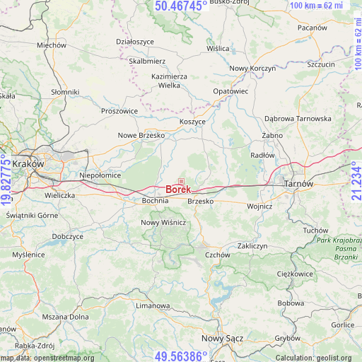
Borek GPS coordinates[2]
50° 1' 4.008" North, 20° 31' 51.132" East
| Map corner | latitude | longitude |
|---|---|---|
| Upper-left | 50.46745°, | 19.82775° |
| Center: | 50.01778°, | 20.53087° |
| Lower-right: | 49.56386°, | 21.234° |
| Map W x H: | 100.5×100.5 km | = 62.4×62.4mi |
| max Lat: | 54.83135° ⇑81.5% North |
| Borek: | 50.01778° |
| min Lat: | ⇓18.5% South 49.21328° |
| min Long | Borek | max Long |
| 14.20249° | 20.53087° | 24.03723° |
| W 65.5%⇐ | ⇒34.5% E |
Elevation
Elevation of Borek is 193 m = 633 ft, and this is 1.6 m = 5 ft above average elevation for this country.
| Max E: |
974 m = 3196 ft | 42.3% |
| Borek | 193 m 633 ft | |
| Avg. | 191.4 m = 628 ft | |
Min E: |
-3 m = -10 ft | 57.7% |
See also: Poland elevation on elevation.city.
Geographical zone
Borek is located in North temperate zone (between Tropic of Cancer and the Arctic Circle). Distance of this North polar circle is 1839.7 km =1143.1 mi to North.| Distance of | km | miles | from Borek |
|---|---|---|---|
| North Pole | 4445.6 | 2762.4 | to North |
| Arctic Circle | 1839.7 | 1143.1 | to North |
| Tropic Cancer | 2955.5 | 1836.5 | to South |
| Equator | 5561.5 | 3455.8 | to South |


Nearby cities:
15 places around Borek: (largest is in red/bold)
• Baczków
6.6 km =4.1 mi,  285°
285°
• Bochnia
9 km =5.6 mi,  232°
232°
• Brzesko
7.6 km =4.7 mi,  135°
135°
• Brzeźnica
7.3 km =4.5 mi,  202°
202°
• Dziewin
8.4 km =5.2 mi,  319°
319°
• Jasień
6.1 km =3.8 mi,  151°
151°
• Jodłówka
3 km =1.9 mi,  155°
155°
• Krzeczów
4.5 km =2.8 mi,  223°
223°
• Okocim
9.2 km =5.7 mi, 146°
• Poręba Spytkowska
8.8 km =5.5 mi,  169°
169°
• Przyborów
9.5 km =5.9 mi,  81°
81°
• Rudy-Rysie
9.1 km =5.7 mi,  57°
57°
• Rzezawa
3.3 km =2.1 mi, 200°
• Strzelce Wielkie
9.2 km =5.7 mi,  22°
22°
• Szczepanów
8.9 km =5.5 mi,  98°
98°
Sources, notices
• [Note1] Compared only with cities in Poland existing in our database
• [Src1] Map data: © OpenStreetMap contributors (CC-BY-SA)
• [Src2] Other city data from geonames.org with taken over terms of usage.
• [Src3] Geographical zone / Annual Mean Temperature by Robert A. Rohde @ Wikipedia
