Brzeźnica geodata
Brzeźnica (Lesser Poland) is a populated place; located in Poland in Europe/Warsaw (GMT+2) time zone. With population of 1,171 people, there are 2238 cities with bigger population in this country. Compared to other cities in Poland, 85% of cities are located further ↑North; 65% of cities are located further ←West and 72.8% of cities have lower elevation than Brzeźnica. Note1


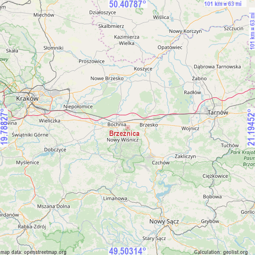
Brzeźnica GPS coordinates[2]
49° 57' 27.468" North, 20° 29' 29.004" East
| Map corner | latitude | longitude |
|---|---|---|
| Upper-left | 50.40787°, | 19.78827° |
| Center: | 49.95763°, | 20.49139° |
| Lower-right: | 49.50314°, | 21.19452° |
| Map W x H: | 100.6×100.6 km | = 62.5×62.5mi |
| max Lat: | 54.83135° ⇑85% North |
| Brzeźnica: | 49.95763° |
| min Lat: | ⇓15% South 49.21328° |
| min Long | Brzeźnica | max Long |
| 14.20249° | 20.49139° | 24.03723° |
| W 65%⇐ | ⇒35% E |
Elevation
Elevation of Brzeźnica is 239 m = 784 ft, and this is 47.6 m = 156 ft above average elevation for this country.
| Max E: |
974 m = 3196 ft | 27.2% |
| Brzeźnica | 239 m 784 ft | |
| Avg. | 191.4 m = 628 ft | |
Min E: |
-3 m = -10 ft | 72.8% |
See also: Poland elevation on elevation.city.
Geographical zone
Brzeźnica is located in North temperate zone (between Tropic of Cancer and the Arctic Circle). Distance of this North polar circle is 1846.4 km =1147.3 mi to North.| Distance of | km | miles | from Brzeźnica |
|---|---|---|---|
| North Pole | 4452.3 | 2766.5 | to North |
| Arctic Circle | 1846.4 | 1147.3 | to North |
| Tropic Cancer | 2948.8 | 1832.3 | to South |
| Equator | 5554.8 | 3451.6 | to South |


Nearby cities:
15 places around Brzeźnica: (largest is in red/bold)
• Baczków
9.2 km =5.7 mi,  337°
337°
• Bochnia
4.6 km =2.9 mi,  286°
286°
• Borek
7.3 km =4.5 mi,  22°
22°
• Brzesko
8.3 km =5.2 mi,  81°
81°
• Damienice
7.8 km =4.8 mi,  299°
299°
• Jasień
5.9 km =3.7 mi, 76°
• Jodłówka
5.7 km =3.5 mi,  45°
45°
• Krzeczów
3.5 km =2.2 mi,  355°
355°
• Nowy Wiśnicz
5.2 km =3.2 mi,  204°
204°
• Okocim
7.9 km =4.9 mi,  97°
97°
• Poręba Spytkowska
4.9 km =3 mi,  113°
113°
• Rzezawa
4 km =2.5 mi,  25°
25°
• Stanisławice
10.5 km =6.5 mi, 287°
• Stary Wiśnicz
3.6 km =2.2 mi,  185°
185°
• Łapczyca
7.7 km =4.8 mi,  271°
271°
Sources, notices
• [Note1] Compared only with cities in Poland existing in our database
• [Src1] Map data: © OpenStreetMap contributors (CC-BY-SA)
• [Src2] Other city data from geonames.org with taken over terms of usage.
• [Src3] Geographical zone / Annual Mean Temperature by Robert A. Rohde @ Wikipedia
