Gromnik geodata
Gromnik (Lesser Poland) is a seat of a third-order administrative division; located in Poland in Europe/Warsaw (GMT+2) time zone. With population of 3,325 people, there are 960 cities with bigger population in this country. Compared to other cities in Poland, 90.2% of cities are located further ↑North; 71.9% of cities are located further ←West and 72.8% of cities have lower elevation than Gromnik. Note1


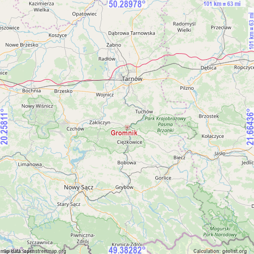
Gromnik GPS coordinates[2]
49° 50' 18.348" North, 20° 57' 40.428" East
| Map corner | latitude | longitude |
|---|---|---|
| Upper-left | 50.28978°, | 20.25811° |
| Center: | 49.83843°, | 20.96123° |
| Lower-right: | 49.38282°, | 21.66436° |
| Map W x H: | 100.8×100.8 km | = 62.6×62.6mi |
| max Lat: | 54.83135° ⇑90.2% North |
| Gromnik: | 49.83843° |
| min Lat: | ⇓9.8% South 49.21328° |
| min Long | Gromnik | max Long |
| 14.20249° | 20.96123° | 24.03723° |
| W 71.9%⇐ | ⇒28.1% E |
Elevation
Elevation of Gromnik is 239 m = 784 ft, and this is 47.6 m = 156 ft above average elevation for this country.
| Max E: |
974 m = 3196 ft | 27.2% |
| Gromnik | 239 m 784 ft | |
| Avg. | 191.4 m = 628 ft | |
Min E: |
-3 m = -10 ft | 72.8% |
See also: Poland elevation on elevation.city.
Geographical zone
Gromnik is located in North temperate zone (between Tropic of Cancer and the Arctic Circle). Distance of this North polar circle is 1859.7 km =1155.6 mi to North.| Distance of | km | miles | from Gromnik |
|---|---|---|---|
| North Pole | 4465.5 | 2774.7 | to North |
| Arctic Circle | 1859.7 | 1155.6 | to North |
| Tropic Cancer | 2935.6 | 1824.1 | to South |
| Equator | 5541.5 | 3443.3 | to South |


Nearby cities:
15 places around Gromnik: (largest is in red/bold)
• Ciężkowice
5.9 km =3.7 mi,  171°
171°
• Janowice
9.3 km =5.8 mi,  309°
309°
• Jastrzębia
7.4 km =4.6 mi,  231°
231°
• Karwodrza
12.7 km =7.9 mi,  39°
39°
• Lubaszowa
5.9 km =3.7 mi,  66°
66°
• Olszyny
11.9 km =7.4 mi,  300°
300°
• Pleśna
9.9 km =6.2 mi,  353°
353°
• Rychwałd
7.8 km =4.8 mi, 347°
• Rzepiennik Marciszewski
3.2 km =2 mi,  105°
105°
• Rzepiennik Strzyżewski
6.5 km =4 mi,  124°
124°
• Siedliska
4.5 km =2.8 mi,  34°
34°
• Siemiechów
4.3 km =2.7 mi,  293°
293°
• Tuchów
9.1 km =5.7 mi,  46°
46°
• Wróblowice
8.8 km =5.5 mi, 299°
• Zakliczyn
11.1 km =6.9 mi,  280°
280°
Sources, notices
• [Note1] Compared only with cities in Poland existing in our database
• [Src1] Map data: © OpenStreetMap contributors (CC-BY-SA)
• [Src2] Other city data from geonames.org with taken over terms of usage.
• [Src3] Geographical zone / Annual Mean Temperature by Robert A. Rohde @ Wikipedia
