Ropa geodata
Ropa (Lesser Poland) is a populated place; located in Poland in Europe/Warsaw (GMT+2) time zone. With population of 3,959 people, there are 824 cities with bigger population in this country. Compared to other cities in Poland, 96.7% of cities are located further ↑North; 73.4% of cities are located further ←West and 90.9% of cities have lower elevation than Ropa. Note1


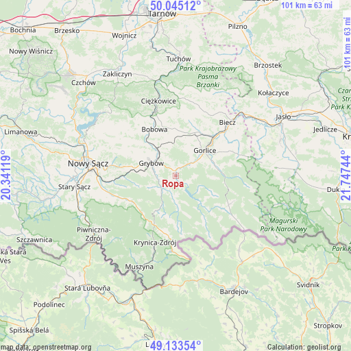
Ropa GPS coordinates[2]
49° 35' 29.256" North, 21° 2' 39.516" East
| Map corner | latitude | longitude |
|---|---|---|
| Upper-left | 50.04512°, | 20.34119° |
| Center: | 49.59146°, | 21.04431° |
| Lower-right: | 49.13354°, | 21.74744° |
| Map W x H: | 101.4×101.4 km | = 63×63mi |
| max Lat: | 54.83135° ⇑96.7% North |
| Ropa: | 49.59146° |
| min Lat: | ⇓3.3% South 49.21328° |
| min Long | Ropa | max Long |
| 14.20249° | 21.04431° | 24.03723° |
| W 73.4%⇐ | ⇒26.6% E |
Elevation
Elevation of Ropa is 342 m = 1122 ft, and this is 150.6 m = 494 ft above average elevation for this country.
| Max E: |
974 m = 3196 ft | 9.1% |
| Ropa | 342 m 1122 ft | |
| Avg. | 191.4 m = 628 ft | |
Min E: |
-3 m = -10 ft | 90.9% |
See also: Poland elevation on elevation.city.
Geographical zone
Ropa is located in North temperate zone (between Tropic of Cancer and the Arctic Circle). Distance of this North polar circle is 1887.1 km =1172.6 mi to North.| Distance of | km | miles | from Ropa |
|---|---|---|---|
| North Pole | 4493 | 2791.8 | to North |
| Arctic Circle | 1887.1 | 1172.6 | to North |
| Tropic Cancer | 2908.1 | 1807 | to South |
| Equator | 5514.1 | 3426.3 | to South |


Nearby cities:
15 places around Ropa: (largest is in red/bold)
• Bobowa
14.8 km =9.2 mi,  331°
331°
• Bystra
8.4 km =5.2 mi,  20°
20°
• Gorlice
11 km =6.8 mi,  49°
49°
• Grybów
7.8 km =4.8 mi,  297°
297°
• Kamionka Wielka
16.1 km =10 mi,  260°
260°
• Kobylanka
15.5 km =9.6 mi,  56°
56°
• Korzenna
17.9 km =11.1 mi,  306°
306°
• Krynica-Zdrój
19.8 km =12.3 mi,  198°
198°
• Kwiatonowice
16.7 km =10.4 mi,  30°
30°
• Lipnica Wielka
17.9 km =11.1 mi, 314°
• Moszczenica
16.5 km =10.3 mi,  12°
12°
• Sękowa
11.6 km =7.2 mi,  72°
72°
• Uście Gorlickie
10.3 km =6.4 mi,  138°
138°
• Łabowa
15.4 km =9.6 mi,  242°
242°
• Łużna
13.5 km =8.4 mi,  0°
0°
Sources, notices
• [Note1] Compared only with cities in Poland existing in our database
• [Src1] Map data: © OpenStreetMap contributors (CC-BY-SA)
• [Src2] Other city data from geonames.org with taken over terms of usage.
• [Src3] Geographical zone / Annual Mean Temperature by Robert A. Rohde @ Wikipedia
